


Tom Stone meets the experts who are predicting that we are at the start of a new connectivity revolution, enabled by multiple low-earth orbit satellite constellations that will transform mobility connectivity, with farreaching implications for tolling, navigation, connected vehicle services and more
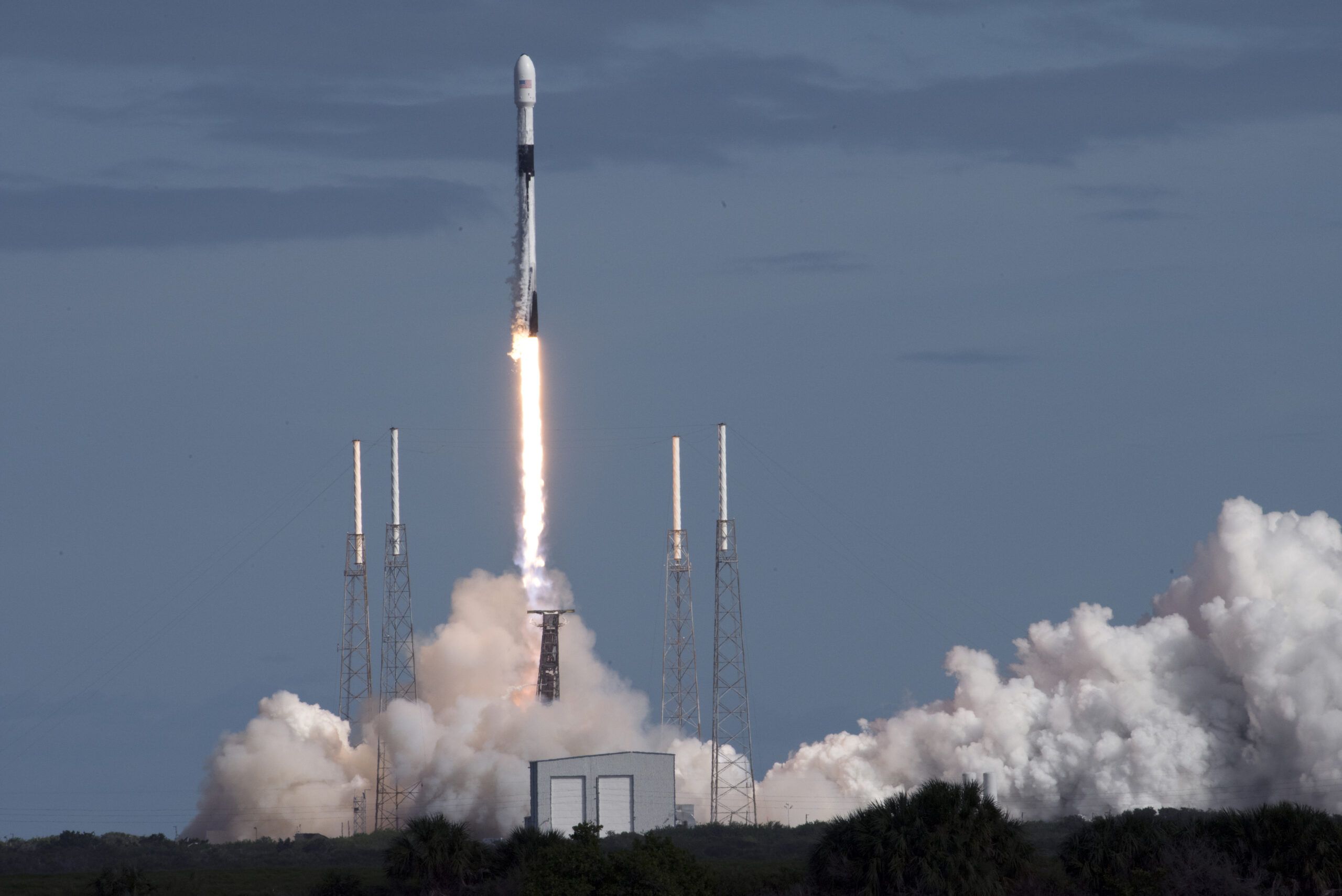
The advent of low-earth orbit (LEO) geostationary satellite constellations such as Starlink, providing near full-earth internet coverage, represents the start of possibly the most significant revolution in connectivity since the birth of the World Wide Web.
For transportation systems, it could eliminate signal blackspots that currently hamper the uniform operation of critical systems that rely on data networks, thus enabling global, seamless connectivity benefiting everything from tolling and emergency responders to autonomous vehicles, and enabling completely new use cases as yet undefined.
Ulrich Hermann, managing partner of Einstein Space Consulting, who spoke at the recent ITS European Congress in Seville in a session led by the European Space Agency, provides a compelling vision of the satellite infrastructure revolution.
Hermann points out that there are currently around 8,000 satellites in LEO, a number that has taken since the first satellite launch of Sputnik in 1959 to be reached. But over the next 10 years it is predicted that this number could soar to at least 100,000 and possibly reach 150,000 before levelling off.

This exponential increase in satellite numbers will be driven not by science or government investment but by commerce – Space X’s Starlink alone is currently planned to have 12,000 satellites but could expand to 42,000. “Every satellite that is produced will be financed,” says Hermann.
The burgeoning commercial possibilities are a product of the physics of LEO constellations “Low earth orbit is about 300 to 600km away,” says Hermann, comparing these to traditional geostationary satellites, which orbit at around 35,000km. This proximity to the earth reduces latency of connections, while the constellation approach eliminates coverage gaps, creating advantages for transportation connectivity.
“True GNSS resilience demands a diverse range of sources using different sensing modalities, coupled with an intelligent fusion algorithm”
“LEO constellations will create an Internet of Things ecosystem,” says Hermann “When things get connected it’s different from connecting people to the internet. Things require a lot of data and LEO constellations can deliver this data. Satellites could one day create not just the Internet of Things but the AI of Things, enabling the artificial brain to take over.”
Hermann predicts that there will be a multitude of uses for LEO constellations that we cannot even imagine yet, comparing this to the early days of the internet. “Think about the speed in the internet end of the 90s,” he says. “Facebook was not possible because the pictures would have taken too long to upload. People will think of new ways to restructure infrastructure, because this will be ubiquitous – you won’t need to dig up the Earth anymore to build infrastructure and get data into cities.” However, there is one predictable use case for LEO constellations – helping to guide autonomous vehicles. Hermann’s studies suggest that even at Level 3 automation, there will be huge advantages of connectivity provided by space technology – particularly with positioning, navigation, and timing (PNT) services. “When you expand the infrastructure, from space to other ecosystems like smart cities, energy and entertainment, the ecosystem of the mobility will grow to almost €1 trillion.”
The European Space Agency’s business applications program has invested over €500 million in space-powered projects, supporting over 1,000 businesses and the mobility sector represents a significant portion of this investment. “The mobility activities, including road, maritime and aviation, occupy one-third of our portfolio,” says Rita Rinaldo, head of projects and studies implementation division at European Space Agency (ESA). “This highlights the importance space has as enabler in this sector.”
Daniela Petrovic, co-founder of Darwin Innovation Group shares the excitement around the new possibilities opening up thanks to satellite connectivity: “It really enables global coverage. Cost was once a barrier that limited satellite adoption, but this is not a significant obstacle anymore.”
Filling coverage gaps today
Jorge Ribeiro, CEO of Allbesmart, highlights how satellite internet will solve one of transportation’s most persistent challenges when delivering connected vehicle systems:coverage gaps, and this is being done with hybrid systems.
His company’s R&D project SATV2X, in partnership with ESA, has demonstrated how terrestrial 5G networks combined with LEO satellite communications in a hybrid system can ensure safety communications reach all vehicles, regardless of location. “For many roads, especially in rural areas, terrestrial coverage isn’t adequate or sustainable for traffic safety services,” says Ribeiro.
The SATV2X solution leverages satellite backhaul to ensure traffic safety messages reach even the most remote locations. The system’s OAiBOX can be installed at roadsides to create a private 5G network to communicate directly with road users, without needing to rely on commercial networks. The OAiBOX can then be connected to satellite communications, thereby quickly and cost-effectively eliminating any coverage blackspots.
“You connect our [roadside] product to a satellite antenna, and that’s how you can have coverage in any place you want without needing a specific chip or change the way the cars communicate,” says Rebeiro. Essentially the system operates a little bit like Wi-Fi based V2X, but without the need for any dedicated OBUs in vehicles.
SATV2X is made possible both by commercially available, low-latency LEO satellite connectivity and high-accuracy GNSS, enhanced with RTK (Real-Time Kinematic) augmentation, to meet these requirements.
Distance-based tolling
Satellite technology is already transforming distance-based tolling by precisely tracking vehicle movements across entire road networks, enabling more sophisticated pricing models based on actual usage, time of day, congestion levels, or environmental impact.
“Cost was once a barrier that limited satellite adoption, but this is not a significant obstacle anymore”
Satellites are currently in use for distance-based tolling on a limited scale in projects around the world. One of the most Enabling AV insurance recent is a collaboration between the Netherlands’ RDW and TotalEnergies, which is using Europe’s GNSS constellation to toll freight trucks by the distance they travel, replacing an existing terrestrial system. “For customers this means greater convenience and seamless cross-border travel, supporting supports both interoperability and customer choice – key priorities for RDW in the development of the Dutch tolling system,” says Jan Strijk, director of toll collection at RDW.
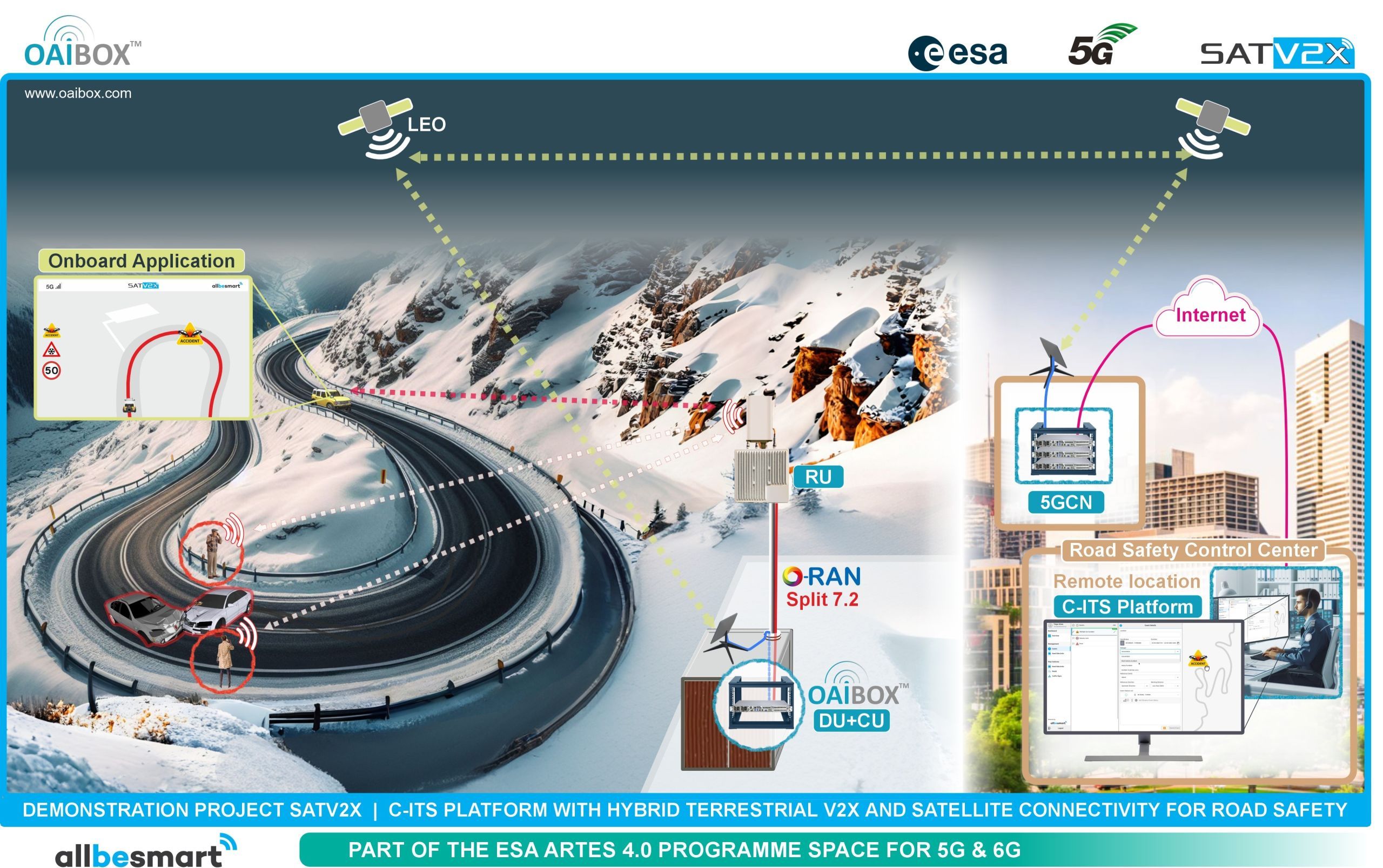
The SATV2X system from Allbesmart uses its satellite-connected OAiBOX installed on roadsides to communicate with cars via 5G in areas with no commercial 5G coverage
LEO constellations have the potential to take interoperability and usability of such tolling systems to the next level, introducing not just accurate geolocation but also high-speed low-latency internet, meaning road pricing information could be relayed to a vehicle dashboard. Any type of vehicle could also traverse multiple countries with automatic distance-based charging, eliminating the need for multiple payment systems.
Infrastructure vulnerabilities
However, as real-world capabilities proliferate Professor Aled Catherall, CTO for advanced engineering consultancy Plextek, highlights the critical risks of our increasing dependence on satellite navigation systems, and the fact that overreliance on them could create a single point of failure that could paralyze transportation systems if satellite services are compromised.
“Hybrid satellite-terrestrial networks are crucial for achieving a truly global connectivity infrastructure”
“The UK Government recently estimated that a GNSS outage for 24 hours would cost the UK economy over £1.4 billion. Precise timing underpins a vast array of critical modern systems” says Catherall. Many systems require “sub-microsecond-level accuracy to function efficiently and reliably,” making them vulnerable to satellite signal degradation.
Recent incidents underscore these concerns. Catherall cites the GPS satellite PRN 37, which experienced a data format change in late May 2025, leading to ‘Dual/Complete GPS Failures’ on various aircraft. Maritime transport has been similarly affected, with GNSS spoofing being the primary reason that the MSC Antonia container ship ran aground in the Red Sea in May this year.
“As the primary source of position information for aircraft, ships, and vehicles, GNSS is vital,” says Catherall. “Even modern precision agriculture is reliant on GNSS for accurate positioning – and its loss would result in lower crop yields such is the entrenchment of GNSS reliance in the modern world.”
The solution, according to Catherall, lies in diversification and redundancy. “True GNSS resilience demands a range of sources using different sensing modalities, coupled with an intelligent fusion algorithm capable of identifying when a PNT source is degraded and prioritizing which sources to use,” he says.
“Satellites could one day create not just the Internet of Things but the AI of Things, enabling the artificial brain to take over”
This approach combines traditional GNSS with alternative technologies including atomic clocks, inertial sensors, visual navigation systems, and even signals from communication satellites not primarily designed for positioning.
“A multi-layered approach, combining an appropriate set of diverse PNT sources with multi-constellation, multi-band GNSS receivers and even CRPAs [Controlled reception pattern antennas designed to resist radio jamming and used to resist GPS spoofing attacks], is essential to ensure the integrity of critical civilian infrastructure,” says Catherall. “The first step in bolstering this resilience is to choose GNSS receivers capable of using a mix of constellations (GPS, Galileo, GLONASS, and BeiDou) across as many of their respective frequency bands as possible.” This provides redundancy against system failures and complicates malicious interference attempts.
“To advanced filter algorithms for data fusion, AI will likely play a role in the next generation of data fusion solutions enabling multiple technologies to be deployed in tandem,” says Catherall
As we consider the need for redundancy, Hermann predicts that within five years, satellite connectivity will replace much terrestrial infrastructure: “What we have today with Iridium [the satellite phone service] or with Starlink, will seem expensive and slow, by comparison. Today we only have 8,000 satellites and we need 150,000. This is going to be a big disruption.”
Despite Hermann’s predictions of the coming satellite connectivity revolution, redundant terrestrial systems would still appear to be wise, particularly as the transition to space-based connectivity is managed, though perhaps one day even redundancy could be provided from space.
Today the European Space Agency focuses on hybrid connectivity solutions to address this kind of medium-term vulnerability of critical systems. “Hybrid satellite-terrestrial networks are crucial for achieving a truly global connectivity infrastructure,” says Rita Rinaldo from ESA. “They can offer ubiquitous internet coverage by reaching areas where terrestrial network cell towers are scarce or non-existent, while also providing seamless connectivity, ensuring smooth transitions between terrestrial and satellite networks without service interruptions.”
Enabling AV insurance
In the world of autonomous vehicles the transition from concept to reality is already underway. Daniela Petrovic, co-founder of Darwin Innovation Group, has been operating one of the UK’s longest-running autonomous vehicle services. Her company’s hybrid satellite-terrestrial communication system has enabled autonomous vehicles to operate safely in both urban and rural environments.
Now the company’s expansion into maritime ports and insurance modeling demonstrates the broader applicability of satellite-enabled transportation solutions. Their data collection capabilities have proven so comprehensive that insurance industry has become interested in using it to develop new insurance models for autonomous vehicles.
“We collected so many data points through this process with so many data points that insurance industry want to use it to create a new insurance model that would enable autonomous vehicles to be available on public roads,” says Petrovic.
This article first appeared in the August issue of TTi


