Traffic Technology TodayTraffic Technology Today
  • News
    • A-D
      • Appointments & Staffing
      • Asset Management
      • Autonomous Vehicles & ADAS
      • Awards
      • Cloud Computing
      • Congestion Reduction
      • Connected Vehicles
      • Covid-19
      • Cybersecurity
      • Data & Modeling
      • Deals, Acquisitions & Mergers
    • E-J
      • Electric vehicles & infrastructure
      • Emissions & Low Emission Zones
      • Enforcement
      • Event News
      • Funding
      • Incident Detection
      • Infrastructure
      • Intersections & Traffic Signals
      • ITS
    • K-S
      • Legal / Government Regulation
      • Machine Vision / ALPR
      • Mapping
      • Mobility as a Service
      • Multimodality & Micromobility
      • Planning, Testing, R&D
      • Public transit
      • Safety
      • Smart Cities
      • Smart Parking
    • T-Z
      • Tolling
      • Traffic counting & categorization
      • Traffic Management
      • Traveler Information Systems
      • Tunnels & Bridges
      • Variable Message Signs
      • Vulnerable Road Users
      • Weather systems
  • Features
    • Features
    • Opinion
  • Online Magazines
    • May 2025
    • March 2025
    • December 2024
    • September 2024
    • June 2024
    • Archive Issues
    • Subscribe Free!
    • > Tolltrans
  • Video & Audio
    • Video
    • Audio
  • Podcast
  • Events
  • Webinars
  • Technology Profiles
LinkedIn YouTube X (Twitter)
Subscribe >
Traffic Technology TodayTraffic Technology Today
  • News
      • Appointments & Staffing
      • Asset Management
      • Autonomous Vehicles & ADAS
      • Awards
      • Cloud Computing
      • Congestion Reduction
      • Connected Vehicles
      • Covid-19
      • Cybersecurity
      • Data & Modeling
      • Deals, Acquisitions & Mergers
      • Electric vehicles & infrastructure
      • Emissions & Low Emission Zones
      • Enforcement
      • Event News
      • Funding
      • Incident Detection
      • Infrastructure
      • Intersections & Traffic Signals
      • ITS
      • Legal / Government Regulation
      • Machine Vision / ALPR
      • Mapping
      • Mobility as a Service
      • Multimodality & Micromobility
      • Planning, Testing, R&D
      • Public transit
      • Safety
      • Smart Cities
      • Smart Parking
      • Tolling
      • Traffic counting & categorization
      • Traffic Management
      • Traveler Information Systems
      • Tunnels & Bridges
      • Variable Message Signs
      • Vulnerable Road Users
      • Weather systems
  • Features
    • Features
    • Opinion
  • Online Magazines
    1. May 2025
    2. March 2025
    3. December 2024
    4. September 2024
    5. June 2024
    6. March 2024
    7. Archive Issues
    8. Subscribe Free!
    9. > Tolltrans
    Featured
    New issue graphic
    May 7, 2025

    Read the new TTi digital magazine online now – May 2025

    ITS By Tom Stone
    Recent
    New issue graphic

    Read the new TTi digital magazine online now – May 2025

    May 7, 2025

    NEW TTi MAGAZINE! Read the March 2025 digital edition online now

    March 21, 2025

    Digital magazine – read the new issue of TTi online for free – December 2024

    December 12, 2024
  • Video & Audio
    • Video
    • Audio
  • Podcast
  • Events
  • Webinars
  • Technology Profiles
LinkedIn YouTube X (Twitter)
Traffic Technology TodayTraffic Technology Today
Data & Modeling

Esri to use real-time Mobileye data for ‘dynamic edge’ HD mapping

Adam FrostBy Adam FrostJuly 25, 20193 Mins Read
Share LinkedIn Twitter Facebook Email

Location intelligence and mapping software systems firm, Esri, has announced a collaboration with Israeli company Mobileye to bring the advanced data collection capabilities of the Intel Company’s advanced driver-assistance systems (ADAS) software into Esri’s platform as native services.

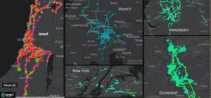
The collaboration will provide Esri’s geographic information system (GIS) customers with the ability to visualize and analyze real-time high-definition (HD) map and location data streaming from sensors on vehicles equipped with Mobileye technology, enabling a new type of living, dynamic map on the Esri platform. Under the agreement, vehicles equipped with Mobileye’s vision system will gather information that will serve as a basis for several new data services on the ArcGIS platform targeting local government, transportation and insurance markets. Over the coming months, Mobileye will publish data into the ArcGIS platform to enable millions of ArcGIS users with dynamic data that serves specific industry applications and will lead to better understanding for both government and commercial customers.

The new agreement vastly expands upon the existing relationship between Esri and Mobileye to include the latest EyeQ4 collection capabilities, bringing advancements in both safety and data collection. The agreement greatly enlarges both the scope of data available to Esri customers, as well as the accessibility to it. The dynamic nature of this new data source will enable better decision-making and greater automation for Esri customers, and ultimately enabling safer streets and smarter communities.

Founded in 1969, Esri GIS software is deployed in more than 350,000 organizations globally, all 50 US state governments, as well as all 15 Executive Departments of the US Government and dozens of independent agencies worldwide. Launched in November 2017, Esri’s original collaboration with Mobileye involved streamed data from Shield+ sensors deployed in municipal buses and city fleets fed into Esri’s ArcGIS platform, where information such as pedestrian and cyclist detection in blindspots could be viewed on Mobileye’s Smart Mobility Dashboard.

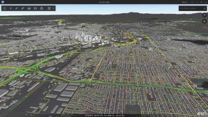
“Mobileye vision from a passing vehicle will automatically inform city workers that a stop sign has an obstructed view for instance,” explained Jim Young, Esri’s head of business development. “The sign will show up on an Esri map and a service crew can be dispatched to fix it, using ArcGIS technology. For our industry, this is the next generation. Just like edge computing, this is edge mapping; using anonymized and generic data captured by vehicle-mounted cameras and computer vision for instant map updates. We are thrilled to be working with Mobileye.”

Lior Sethon, Mobileye’s vice president of intelligent mobility solutions, commented, “We live in a world that changes every day. Our data solutions help reflect those constant changes in high quality resolution. With Esri, we are extending the value of our HD maps beyond the automotive market, for the broad range of Esri customer use-cases.”

Share. Twitter LinkedIn Facebook Email
Previous ArticleIndra-led Transforming Transport program declared best European big data project
Next Article Sensys Networks launches new multi-source traffic detection system
Adam Frost

Adam joined the company in 1994, and has been News Editor of TTT since 2009. In his other role as Circulation Manager, he helped create the original Traffic Technology International distribution list 23 years ago, and has been working on it ever since. Outside of work, he is a keen fisherman, runs a drumming band, and plays an ancient version of cricket.

Related Posts

A picture of IKIO and bitsensing signing the MoU
ITS

bitsensing and IKIO Technologies to deploy AI-based ITS solution in India

June 4, 20252 Mins Read
Connected Vehicles

ITS SEVILLE VIDEO: Landmark agreement incentivises automotive data sharing

May 21, 20251 Min Read
Stylized illustration of the Scream painting by Edvard Munch featuring screaming head and a circuit board background
Data & Modeling

FEATURE: Synthetic data – What is it? And can we trust it?

May 15, 202510 Mins Read
Latest Posts
A young woman with long dark hair singing on stage

APCOA to manage parking at Utilita Arena Birmingham for Katy Perry and Iron Maiden

June 12, 2025
White man with short hair smiling on a sunny day in front of green bush

OPINION: Why lower crash rates don’t always indicate safer roads

June 11, 2025
Busy city - bus passing by with the British Union Jack on the side of bus - motion blur effect - fractal pattern effect - abstract art illustration

UK Spending Review includes billions to decarbonize transport – industry reacts

June 11, 2025
FREE WEEKLY NEWS EMAIL!

Get the ‘best of the week’ from TrafficTechnologyToday.com direct to your inbox every Thursday


Supplier Spotlights
Our Social Channels
  • Twitter
  • YouTube
  • LinkedIn
Getting in Touch
  • Free Email Newsletters
  • Contact Us
  • About Us
  • Supplier Spotlight

Upcoming Events

Jun 17
June 17 - June 19

Intertraffic Americas – Mexico City 2025

Jun 18
June 18 - June 19

Move London 2025

Jul 26
July 26 - July 29

2025 Maintenance, Engineering & Roadway Operations Workshop

View Calendar
© 2023 Mark Allen Group Ltd | All Rights Reserved
  • Cookie Policy
  • Privacy Policy
  • Terms & Conditions

Type above and press Enter to search. Press Esc to cancel.