Traffic Technology TodayTraffic Technology Today
  • News
    • A-D
      • Appointments & Staffing
      • Asset Management
      • Autonomous Vehicles & ADAS
      • Awards
      • Cloud Computing
      • Congestion Reduction
      • Connected Vehicles
      • Covid-19
      • Cybersecurity
      • Data & Modeling
      • Deals, Acquisitions & Mergers
    • E-J
      • Electric vehicles & infrastructure
      • Emissions & Low Emission Zones
      • Enforcement
      • Event News
      • Funding
      • Incident Detection
      • Infrastructure
      • Intersections & Traffic Signals
      • ITS
    • K-S
      • Legal / Government Regulation
      • Machine Vision / ALPR
      • Mapping
      • Mobility as a Service
      • Multimodality & Micromobility
      • Planning, Testing, R&D
      • Public transit
      • Safety
      • Smart Cities
      • Smart Parking
    • T-Z
      • Tolling
      • Traffic counting & categorization
      • Traffic Management
      • Traveler Information Systems
      • Tunnels & Bridges
      • Variable Message Signs
      • Vulnerable Road Users
      • Weather systems
  • Features
    • Features
    • Opinion
  • Online Magazines
    • May 2025
    • March 2025
    • December 2024
    • September 2024
    • June 2024
    • Archive Issues
    • Subscribe Free!
    • > Tolltrans
  • Video & Audio
    • Video
    • Audio
  • Podcast
  • Events
  • Webinars
  • Technology Profiles
LinkedIn YouTube X (Twitter)
Subscribe >
Traffic Technology TodayTraffic Technology Today
  • News
      • Appointments & Staffing
      • Asset Management
      • Autonomous Vehicles & ADAS
      • Awards
      • Cloud Computing
      • Congestion Reduction
      • Connected Vehicles
      • Covid-19
      • Cybersecurity
      • Data & Modeling
      • Deals, Acquisitions & Mergers
      • Electric vehicles & infrastructure
      • Emissions & Low Emission Zones
      • Enforcement
      • Event News
      • Funding
      • Incident Detection
      • Infrastructure
      • Intersections & Traffic Signals
      • ITS
      • Legal / Government Regulation
      • Machine Vision / ALPR
      • Mapping
      • Mobility as a Service
      • Multimodality & Micromobility
      • Planning, Testing, R&D
      • Public transit
      • Safety
      • Smart Cities
      • Smart Parking
      • Tolling
      • Traffic counting & categorization
      • Traffic Management
      • Traveler Information Systems
      • Tunnels & Bridges
      • Variable Message Signs
      • Vulnerable Road Users
      • Weather systems
  • Features
    • Features
    • Opinion
  • Online Magazines
    1. May 2025
    2. March 2025
    3. December 2024
    4. September 2024
    5. June 2024
    6. March 2024
    7. Archive Issues
    8. Subscribe Free!
    9. > Tolltrans
    Featured
    New issue graphic
    May 7, 2025

    Read the new TTi digital magazine online now – May 2025

    ITS By Tom Stone
    Recent
    New issue graphic

    Read the new TTi digital magazine online now – May 2025

    May 7, 2025

    NEW TTi MAGAZINE! Read the March 2025 digital edition online now

    March 21, 2025

    Digital magazine – read the new issue of TTi online for free – December 2024

    December 12, 2024
  • Video & Audio
    • Video
    • Audio
  • Podcast
  • Events
  • Webinars
  • Technology Profiles
LinkedIn YouTube X (Twitter)
Traffic Technology TodayTraffic Technology Today
Data & Modeling

Australian university uses Google Street View to manage roadside infrastructure

Adam FrostBy Adam FrostJune 20, 20193 Mins Read
Share LinkedIn Twitter Facebook Email

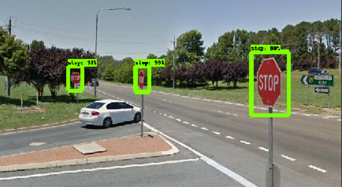
Geospatial scientists from Australia’s RMIT University in Melbourne have developed a new program that uses artificial intelligence (AI) to monitor street signs needing replacement or repair by tapping into Google’s Street View images.

Highway authorities worldwide currently spend large amounts of time and money monitoring and recording the geo-location of traffic infrastructure manually, a task which also exposes workers to unnecessary risks from passing vehicles. The RMIT’s fully-automated system is trained using AI-powered object detection to identify street signs in the freely available images. Results just published in the journal of ‘Computers, Environment and Urban Systems’ show the system detects signs with near 96% accuracy, identifies their type with near 98% accuracy and can record their precise geo location from the 2D images. The research team found during investigations that mandatory GPS location data in existing street sign databases was often inaccurate, sometimes up to 33 feet (10m) off.

“The proof-of-concept model was trained to see ‘stop’ and ‘give way’ signs, but can be trained to identify many other inputs and is easily scalable for use by local governments and traffic authorities. Councils have requirements to monitor this infrastructure, but currently with no cheap or efficient way to do so,” explained the study’s lead author and RMIT geospatial science student, Andrew Campbell. “By using free and open source tools, we’ve now developed a fully automated system for doing that job, and doing it more accurately. Tracking these signs manually by people who may not be trained geoscientists introduces human error into the database. Our system, once set up, can be used by any spatial analyst; you just tell the system which area you want to monitor and it looks after it for you.”

RMIT geospatial scientist and project co-lead, Dr Chayn Sun, said, “The fact that some councils are already attaching cameras onto rubbish trucks to gather street footage shows how valuable visual data is becoming, given what technology could now do with it. This imagery is critical for local governments in monitoring and managing assets and with the huge amount of geospatial applications flourishing, this information will only become more valuable. Ours is one of several early applications for this to meet a specific industry need, but a whole lot more will emerge in coming years. Footage from other sources, like that from rubbish truck cameras or any other geo-referenced imagery of the road network collected by councils, can also be fed into the system. Where footage is already being gathered, our research can provide councils with an economical tool to drive insights and data from this existing resource.”

The project was co-led by Sun and fellow RMIT geospatial scientist, Dr Alan Both, from the university’s Center for Urban Research. The RMIT research team is currently working with local governments on heat intervention strategies using Google Street View images to analyze street tree shade.

Share. Twitter LinkedIn Facebook Email
Previous ArticleTRL expert highlights dangers of hands-free phone use at Parliamentary hearing
Next Article UDOT’s new bike boxes explained
Adam Frost

Adam joined the company in 1994, and has been News Editor of TTT since 2009. In his other role as Circulation Manager, he helped create the original Traffic Technology International distribution list 23 years ago, and has been working on it ever since. Outside of work, he is a keen fisherman, runs a drumming band, and plays an ancient version of cricket.

Related Posts

Crash barrier
Infrastructure

INTERTRAFFIC AMERICAS: TrafFix showcases crash cushion solutions

June 17, 20252 Mins Read
A aerial view of a wide bridge over a road covered with grass and vegetation
Infrastructure

Lower Thames Crossing £1bn funding confirmed as new images released

June 10, 20253 Mins Read
Bixby Creek Bridge in Big Sur, CA, USA towards the south
Funding

USDOT announces multi-billion-dollar bridge funding

June 3, 20252 Mins Read
Latest Posts
Crash barrier

INTERTRAFFIC AMERICAS: TrafFix showcases crash cushion solutions

June 17, 2025
A young woman with long dark hair singing on stage

APCOA to manage parking at Utilita Arena Birmingham for Katy Perry and Iron Maiden

June 12, 2025
White man with short hair smiling on a sunny day in front of green bush

OPINION: Why lower crash rates don’t always indicate safer roads

June 11, 2025
FREE WEEKLY NEWS EMAIL!

Get the ‘best of the week’ from TrafficTechnologyToday.com direct to your inbox every Thursday


Supplier Spotlights
Our Social Channels
  • Twitter
  • YouTube
  • LinkedIn
Getting in Touch
  • Free Email Newsletters
  • Contact Us
  • About Us
  • Supplier Spotlight

Upcoming Events

Jun 17
June 17 - June 19

Intertraffic Americas – Mexico City 2025

Jun 18
June 18 - June 19

Move London 2025

Jul 26
July 26 - July 29

2025 Maintenance, Engineering & Roadway Operations Workshop

View Calendar
© 2023 Mark Allen Group Ltd | All Rights Reserved
  • Cookie Policy
  • Privacy Policy
  • Terms & Conditions

Type above and press Enter to search. Press Esc to cancel.