Traffic Technology TodayTraffic Technology Today
  • News
    • A-D
      • Appointments & Staffing
      • Asset Management
      • Autonomous Vehicles & ADAS
      • Awards
      • Cloud Computing
      • Congestion Reduction
      • Connected Vehicles
      • Covid-19
      • Cybersecurity
      • Data & Modeling
      • Deals, Acquisitions & Mergers
    • E-J
      • Electric vehicles & infrastructure
      • Emissions & Low Emission Zones
      • Enforcement
      • Event News
      • Funding
      • Incident Detection
      • Infrastructure
      • Intersections & Traffic Signals
      • ITS
    • K-S
      • Legal / Government Regulation
      • Machine Vision / ALPR
      • Mapping
      • Mobility as a Service
      • Multimodality & Micromobility
      • Planning, Testing, R&D
      • Public transit
      • Safety
      • Smart Cities
      • Smart Parking
    • T-Z
      • Tolling
      • Traffic counting & categorization
      • Traffic Management
      • Traveler Information Systems
      • Tunnels & Bridges
      • Variable Message Signs
      • Vulnerable Road Users
      • Weather systems
  • Features
    • Features
    • Opinion
  • Online Magazines
    • May 2025
    • March 2025
    • December 2024
    • September 2024
    • June 2024
    • Archive Issues
    • Subscribe Free!
    • > Tolltrans
  • Video & Audio
    • Video
    • Audio
  • Podcast
  • Events
  • Webinars
  • Technology Profiles
LinkedIn YouTube X (Twitter)
Subscribe >
Traffic Technology TodayTraffic Technology Today
  • News
      • Appointments & Staffing
      • Asset Management
      • Autonomous Vehicles & ADAS
      • Awards
      • Cloud Computing
      • Congestion Reduction
      • Connected Vehicles
      • Covid-19
      • Cybersecurity
      • Data & Modeling
      • Deals, Acquisitions & Mergers
      • Electric vehicles & infrastructure
      • Emissions & Low Emission Zones
      • Enforcement
      • Event News
      • Funding
      • Incident Detection
      • Infrastructure
      • Intersections & Traffic Signals
      • ITS
      • Legal / Government Regulation
      • Machine Vision / ALPR
      • Mapping
      • Mobility as a Service
      • Multimodality & Micromobility
      • Planning, Testing, R&D
      • Public transit
      • Safety
      • Smart Cities
      • Smart Parking
      • Tolling
      • Traffic counting & categorization
      • Traffic Management
      • Traveler Information Systems
      • Tunnels & Bridges
      • Variable Message Signs
      • Vulnerable Road Users
      • Weather systems
  • Features
    • Features
    • Opinion
  • Online Magazines
    1. May 2025
    2. March 2025
    3. December 2024
    4. September 2024
    5. June 2024
    6. March 2024
    7. Archive Issues
    8. Subscribe Free!
    9. > Tolltrans
    Featured
    New issue graphic
    May 7, 2025

    Read the new TTi digital magazine online now – May 2025

    ITS By Tom Stone
    Recent
    New issue graphic

    Read the new TTi digital magazine online now – May 2025

    May 7, 2025

    NEW TTi MAGAZINE! Read the March 2025 digital edition online now

    March 21, 2025

    Digital magazine – read the new issue of TTi online for free – December 2024

    December 12, 2024
  • Video & Audio
    • Video
    • Audio
  • Podcast
  • Events
  • Webinars
  • Technology Profiles
LinkedIn YouTube X (Twitter)
Traffic Technology TodayTraffic Technology Today
Asset Management

Ordnance Survey data to help TfL reduce low bridge crashes

Adam FrostBy Adam FrostOctober 14, 20193 Mins Read
Share LinkedIn Twitter Facebook Email

The UK’s mapping agency Ordnance Survey (OS) is providing Transport for London (TfL) with a verified dataset on height restrictions of tunnels and bridges to enhance road safety and help vehicles avoid unnecessary collisions that impact drivers and rail passengers across the capital. 

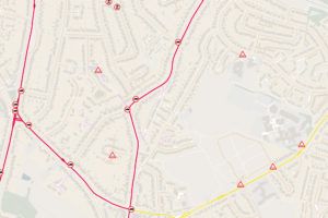
The free to use OS dataset will provide freight and delivery operators, as well as construction companies, developers and academics, with more detailed information about height restrictions on low bridges, tunnels and barriers across London roads. The data will cover all bridge structures within the Greater London boundary/M25 orbital motorway and will see structures grouped into five specific groups. These bridges can suffer from strikes by oversized vehicles, such as trucks or cranes, despite signage on the approaches. Releasing the data will allow fleet operators to ensure that vehicles of certain heights are not diverted under the structures incorrectly, potentially causing significant structural damage and delays. 

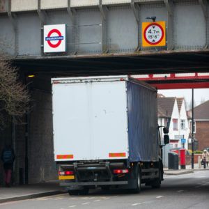
Analysis by TfL suggests that, on average, there are at least two bridge strikes a month across London. Bridge strikes can be dangerous and not only cause delays to road users, but also to people traveling on the Tube or rail services that often run across them. Earlier this year, TfL was alerted to a vehicle strike on a 15.7 feet (4.8m) high rail bridge in Old Street, which carries the East London line. Although the road was only closed for around 20 minutes while the structure was assessed by engineers for damage, London Overground services were impacted for around two and a half hours. This led to additional and unnecessary disruption for thousands of commuters that could have been easily avoided. Both TfL and OS hope that the new free to use data will enable freight and heavy transport operators to better route high vehicles away from these structures across the capital, reducing the chances of impact and saving money in avoidable structural repairs. 

“Every day, millions of road freight deliveries are made across London, and yet, in this digitally connected age, it is still alarming how often bridge strikes can occur,” noted Emily Herreras-Griffiths, travel demand management interim program director at TfL. “For many years, we have brought together the road freight industry to tackle many issues and I’m delighted that we have been able to work with Ordnance Survey to provide a ‘single source of data’ for bridge heights across London. I encourage all freight operators to use this data to ensure their systems are consistently accurate, helping drivers and their vehicles avoid unnecessary collisions, which can impact both drivers and rail passengers.” 

John Kimmance, director of government and partner engagement at OS, said, “Every day the public and private sector are using our MasterMap Highways data to make better decisions about Britain’s road network. From reducing carbon emissions and fuel costs through route optimization, to improving road safety and congestion levels, our data is an essential source information when maintaining a safe and efficient transport infrastructure.” 

Share. Twitter LinkedIn Facebook Email
Previous ArticleWeb-based lane closure and work zone management system debuted
Next Article US Army bases to prepare for AVs and smart mobility
Adam Frost

Adam joined the company in 1994, and has been News Editor of TTT since 2009. In his other role as Circulation Manager, he helped create the original Traffic Technology International distribution list 23 years ago, and has been working on it ever since. Outside of work, he is a keen fisherman, runs a drumming band, and plays an ancient version of cricket.

Related Posts

Picture of two Devon Air Ambulance helicopters
Safety

New UK research center aims to reduce serious road collisions

May 23, 20252 Mins Read
Connected Vehicles

ITS SEVILLE VIDEO: Landmark agreement incentivises automotive data sharing

May 21, 20251 Min Read
Stylized illustration of the Scream painting by Edvard Munch featuring screaming head and a circuit board background
Data & Modeling

FEATURE: Synthetic data – What is it? And can we trust it?

May 15, 202510 Mins Read
Latest Posts
A young woman with long dark hair singing on stage

APCOA to manage parking at Utilita Arena Birmingham for Katy Perry and Iron Maiden

June 12, 2025
White man with short hair smiling on a sunny day in front of green bush

OPINION: Why lower crash rates don’t always indicate safer roads

June 11, 2025
Busy city - bus passing by with the British Union Jack on the side of bus - motion blur effect - fractal pattern effect - abstract art illustration

UK Spending Review includes billions to decarbonize transport – industry reacts

June 11, 2025
FREE WEEKLY NEWS EMAIL!

Get the ‘best of the week’ from TrafficTechnologyToday.com direct to your inbox every Thursday


Supplier Spotlights
Our Social Channels
  • Twitter
  • YouTube
  • LinkedIn
Getting in Touch
  • Free Email Newsletters
  • Contact Us
  • About Us
  • Supplier Spotlight

Upcoming Events

Jun 17
June 17 - June 19

Intertraffic Americas – Mexico City 2025

Jun 18
June 18 - June 19

Move London 2025

Jul 26
July 26 - July 29

2025 Maintenance, Engineering & Roadway Operations Workshop

View Calendar
© 2023 Mark Allen Group Ltd | All Rights Reserved
  • Cookie Policy
  • Privacy Policy
  • Terms & Conditions

Type above and press Enter to search. Press Esc to cancel.