Traffic Technology TodayTraffic Technology Today
  • News
    • A-D
      • Appointments & Staffing
      • Asset Management
      • Autonomous Vehicles & ADAS
      • Awards
      • Cloud Computing
      • Congestion Reduction
      • Connected Vehicles
      • Covid-19
      • Cybersecurity
      • Data & Modeling
      • Deals, Acquisitions & Mergers
    • E-J
      • Electric vehicles & infrastructure
      • Emissions & Low Emission Zones
      • Enforcement
      • Event News
      • Funding
      • Incident Detection
      • Infrastructure
      • Intersections & Traffic Signals
      • ITS
    • K-S
      • Legal / Government Regulation
      • Machine Vision / ALPR
      • Mapping
      • Mobility as a Service
      • Multimodality & Micromobility
      • Planning, Testing, R&D
      • Public transit
      • Safety
      • Smart Cities
      • Smart Parking
    • T-Z
      • Tolling
      • Traffic counting & categorization
      • Traffic Management
      • Traveler Information Systems
      • Tunnels & Bridges
      • Variable Message Signs
      • Vulnerable Road Users
      • Weather systems
  • Features
    • Features
    • Opinion
  • Online Magazines
    • May 2025
    • March 2025
    • December 2024
    • September 2024
    • June 2024
    • Archive Issues
    • Subscribe Free!
    • > Tolltrans
  • Video & Audio
    • Video
    • Audio
  • Podcast
  • Events
  • Webinars
  • Technology Profiles
LinkedIn YouTube X (Twitter)
Subscribe >
Traffic Technology TodayTraffic Technology Today
  • News
      • Appointments & Staffing
      • Asset Management
      • Autonomous Vehicles & ADAS
      • Awards
      • Cloud Computing
      • Congestion Reduction
      • Connected Vehicles
      • Covid-19
      • Cybersecurity
      • Data & Modeling
      • Deals, Acquisitions & Mergers
      • Electric vehicles & infrastructure
      • Emissions & Low Emission Zones
      • Enforcement
      • Event News
      • Funding
      • Incident Detection
      • Infrastructure
      • Intersections & Traffic Signals
      • ITS
      • Legal / Government Regulation
      • Machine Vision / ALPR
      • Mapping
      • Mobility as a Service
      • Multimodality & Micromobility
      • Planning, Testing, R&D
      • Public transit
      • Safety
      • Smart Cities
      • Smart Parking
      • Tolling
      • Traffic counting & categorization
      • Traffic Management
      • Traveler Information Systems
      • Tunnels & Bridges
      • Variable Message Signs
      • Vulnerable Road Users
      • Weather systems
  • Features
    • Features
    • Opinion
  • Online Magazines
    1. May 2025
    2. March 2025
    3. December 2024
    4. September 2024
    5. June 2024
    6. March 2024
    7. Archive Issues
    8. Subscribe Free!
    9. > Tolltrans
    Featured
    New issue graphic
    May 7, 2025

    Read the new TTi digital magazine online now – May 2025

    ITS By Tom Stone
    Recent
    New issue graphic

    Read the new TTi digital magazine online now – May 2025

    May 7, 2025

    NEW TTi MAGAZINE! Read the March 2025 digital edition online now

    March 21, 2025

    Digital magazine – read the new issue of TTi online for free – December 2024

    December 12, 2024
  • Video & Audio
    • Video
    • Audio
  • Podcast
  • Events
  • Webinars
  • Technology Profiles
LinkedIn YouTube X (Twitter)
Traffic Technology TodayTraffic Technology Today
Machine Vision / ALPR

Geodetics drone mapping system incorporates Quanergy’s lidar sensor

Adam FrostBy Adam FrostSeptember 20, 20193 Mins Read
Share LinkedIn Twitter Facebook Email

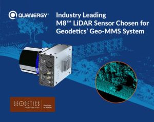
Lidar (Light Detection and Ranging) sensors and smart sensing solutions firm, Quanergy Systems Inc., has revealed that its M8 lidar sensor has been selected for the Geo-MMS lidar product line by Geodetics, a leading provider of lidar-based drone mapping systems.

Quanergy’s M8 unit offers the industry’s leading lidar solution with the best performance in the market for mapping. With a compact form factor, it has a high point cloud density that is three times that of competitors and a more accurate range and fine resolution than the current market offering, with 0.033-degree angular resolution and 3cm range accuracy. After conducting a series of drive and flight tests to validate the sensor’s performance, Geodetics has added the M8 sensor to its lidar mapping and photogrammetry systems offering the best range and number of returns for Geo-MMS customers. By incorporating Quanergy’s M8 sensors and making necessary updates to Geodetics existing system, the Geo-MMS product line now provides up to 410 feet (125m) effective range and three returns for any drone mapping applications, allowing it to fly at the highest altitudes with the highest resolution for commercial drones.

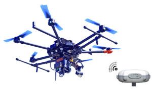
Geodetic’s Geo-MMS system is a cost-effective modular system for vehicle and drone-based photogrammetry, lidar mapping and creation of RGB/multi-spectral colorized lidar point clouds. Geodetics customers have used the Geo-MMS product line in a wide variety of survey applications, including drone mapping in transport infrastructure projects. The traditional management of roads and highway systems is expensive and time consuming for transportation agencies around the world as it involves a full crew equipped with expensive instruments, such as total stations and/or terrestrial laser scanners. Using drone-mounted lidar systems such as the Geo-MMS road mapping system, data collection and data post-processing tasks are performed far more efficiently, significantly reducing time and cost.

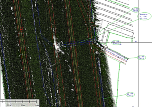
“At its core, lidar is a mapping technology, and while it has made its name as an important component for autonomous vehicles, these detailed maps are crucial for many other industries as well,” said Dr Louay Eldada, CEO of Quanergy. “Geodetics is one of the most accomplished companies in drone mapping and the fact that they have selected to partner with us speaks volumes to the superiority of our lidar sensors.”

Dr Lydia Bock, CEO of Geodetics, said, “The range and number of returns offered by Quanergy’s M8 make it the most compelling option for our customers. With the integration of the M8 with our Geo-MMS product line, we can now offer the most advanced drone mapping systems on the market.”

Share. Twitter LinkedIn Facebook Email
Previous ArticleGSMA and 5GAA to accelerate deployment of C-V2X
Next Article Qualcomm’s Smart Cities Accelerator Program expands
Adam Frost

Adam joined the company in 1994, and has been News Editor of TTT since 2009. In his other role as Circulation Manager, he helped create the original Traffic Technology International distribution list 23 years ago, and has been working on it ever since. Outside of work, he is a keen fisherman, runs a drumming band, and plays an ancient version of cricket.

Related Posts

Blue Ouster lidar installed on a signalized intersection.
Intersections & Traffic Signals

Utah DOT to deploy lidar with Econolite using Ouster technology

March 13, 20253 Mins Read
Artificial Intelligence (AI)

CES 2025: Here Technologies’ AI-powered mapping technology

January 3, 20253 Mins Read
Intersections & Traffic Signals

Seyond launches lidar-based traffic management platform

October 10, 20243 Mins Read
Latest Posts
New issue graphic

Read the new TTi digital magazine online now – May 2025

May 7, 2025

Adept Live Labs 2 launches pledge to drive decarbonisation across UK highways

May 7, 2025

AUDIO: What is distracted driving?

May 7, 2025
FREE WEEKLY NEWS EMAIL!

Get the ‘best of the week’ from TrafficTechnologyToday.com direct to your inbox every Thursday


Supplier Spotlights
Our Social Channels
  • Twitter
  • YouTube
  • LinkedIn
Getting in Touch
  • Free Email Newsletters
  • Contact Us
  • Meet the Editors
  • Supplier Spotlight

Upcoming Events

May 19
May 19 - May 21

ITS European Congress – Seville 2025

May 21
May 21 - May 22

Traffex

Jun 17
June 17 - June 19

Intertraffic Americas – Mexico City 2025

View Calendar
© 2023 Mark Allen Group Ltd | All Rights Reserved
  • Cookie Policy
  • Privacy Policy
  • Terms & Conditions

Type above and press Enter to search. Press Esc to cancel.