


Transport for London (TfL) has launched a series of new maps during National Walking Month showing the walking times and distances between stations, with the aim of promoting active travel and encouraging people to reap the benefits of travelling on foot.
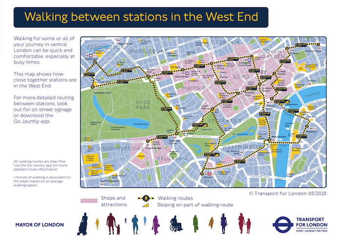
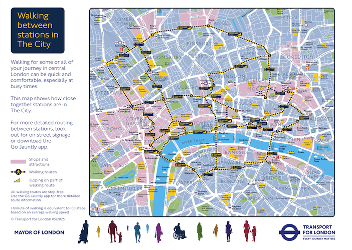
New downloadable street maps of the City of London and the West End show walking routes, distance in meters and how long it takes to travel on foot between TfL stations in each of the areas, demonstrating the short distances between hubs.
Areas with shops and amenities are shown on the maps, with major attractions such as Hamleys, the Tate Modern and Barbican pinpointed, while sections with sloping terrain are also marked out to help inform people with accessibility needs.
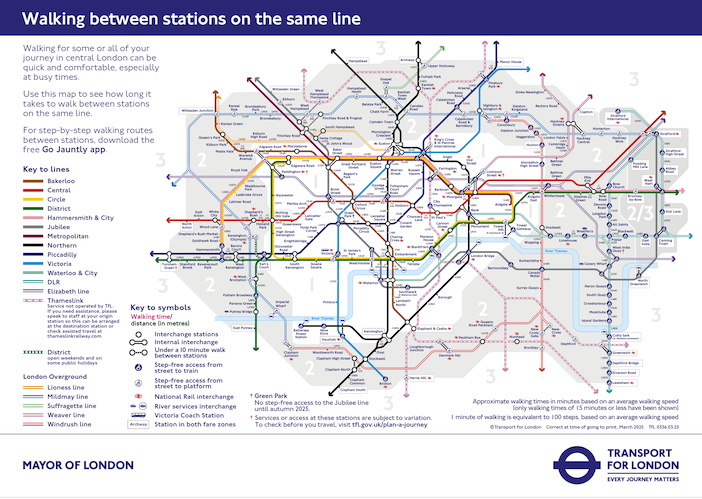
A third map, based on the standard Tube map, shows walking times and distances between stations in Zones 1-2, incorporating all modes of transport on the TfL network, such as the DLR, Elizabeth Line and London Overground.
The national charity Living Streets, whose annual campaign National Walking Month has run throughout May, says that inactivity is linked to 20 chronic conditions and diseases, and is responsible for one in six deaths in the UK. This year, the charity is calling on people to discover the #MagicOfWalking and celebrate how walking can boost physical and mental health and the economy.
TfL is encouraging people to build walking into their journeys as it continues to work towards the ambitious target in the Mayor’s Transport Strategy of 80% of all journeys being made on foot, by cycle or on public transport by 2041. This could involve swapping part of a longer journey on public transport for walking, or replacing a car journey for improved health as well as reduced congestion.
Walking and cycling commissioner, Will Norman, said, “Walking, especially when combined with public transport, is one of the most effective ways to reduce our reliance on cars. It also improves air quality, reduces congestion and road danger and connects communities. I encourage Londoners to swap part of their journeys for walking and use TfL’s new walking maps to explore more of what our city has to offer on foot.”
Christina Calderato, TfL’s director of strategy, added, “Walking has so many advantages, from keeping us fit and healthy, to reducing congestion on our roads. In London we’re also spoiled with so much history and intrigue on our streets, which makes travelling by foot more rewarding as we discover cobbled streets, hidden parks and neighborhood restaurants we never knew about. With the warmer weather with us, now is the perfect time to download one of our new maps and get exploring.”
Last March, TfL launched the Green Link Walk, a 15-mile route between Epping Forest and Peckham, spanning several London boroughs and linking almost 40 areas of green space and other Walk London routes. It is the eighth route to be included in the Walk London Network.
In September last year, TfL also teamed up with Go Jauntly to launch six self-guided walks linked to the new London Overground line names, while a host of other walks, including short walks and Nature Trails, are available on the TfL website.
The three new walking maps are available on the TfL website here, along with links to maps and wayfinding for the Walk London Network.


