Traffic Technology TodayTraffic Technology Today
  • News
    • A-D
      • Appointments & Staffing
      • Asset Management
      • Autonomous Vehicles & ADAS
      • Awards
      • Cloud Computing
      • Congestion Reduction
      • Connected Vehicles
      • Covid-19
      • Cybersecurity
      • Data & Modeling
      • Deals, Acquisitions & Mergers
    • E-J
      • Electric vehicles & infrastructure
      • Emissions & Low Emission Zones
      • Enforcement
      • Event News
      • Funding
      • Incident Detection
      • Infrastructure
      • Intersections & Traffic Signals
      • ITS
    • K-S
      • Legal / Government Regulation
      • Machine Vision / ALPR
      • Mapping
      • Mobility as a Service
      • Multimodality & Micromobility
      • Planning, Testing, R&D
      • Public transit
      • Safety
      • Smart Cities
      • Smart Parking
    • T-Z
      • Tolling
      • Traffic counting & categorization
      • Traffic Management
      • Traveler Information Systems
      • Tunnels & Bridges
      • Variable Message Signs
      • Vulnerable Road Users
      • Weather systems
  • Features
    • Features
    • Opinion
  • Online Magazines
    • May 2025
    • March 2025
    • December 2024
    • September 2024
    • June 2024
    • Archive Issues
    • Subscribe Free!
    • > Tolltrans
  • Video & Audio
    • Video
    • Audio
  • Podcast
  • Events
  • Webinars
  • Technology Profiles
LinkedIn YouTube X (Twitter)
Subscribe >
Traffic Technology TodayTraffic Technology Today
  • News
      • Appointments & Staffing
      • Asset Management
      • Autonomous Vehicles & ADAS
      • Awards
      • Cloud Computing
      • Congestion Reduction
      • Connected Vehicles
      • Covid-19
      • Cybersecurity
      • Data & Modeling
      • Deals, Acquisitions & Mergers
      • Electric vehicles & infrastructure
      • Emissions & Low Emission Zones
      • Enforcement
      • Event News
      • Funding
      • Incident Detection
      • Infrastructure
      • Intersections & Traffic Signals
      • ITS
      • Legal / Government Regulation
      • Machine Vision / ALPR
      • Mapping
      • Mobility as a Service
      • Multimodality & Micromobility
      • Planning, Testing, R&D
      • Public transit
      • Safety
      • Smart Cities
      • Smart Parking
      • Tolling
      • Traffic counting & categorization
      • Traffic Management
      • Traveler Information Systems
      • Tunnels & Bridges
      • Variable Message Signs
      • Vulnerable Road Users
      • Weather systems
  • Features
    • Features
    • Opinion
  • Online Magazines
    1. May 2025
    2. March 2025
    3. December 2024
    4. September 2024
    5. June 2024
    6. March 2024
    7. Archive Issues
    8. Subscribe Free!
    9. > Tolltrans
    Featured
    New issue graphic
    May 7, 2025

    Read the new TTi digital magazine online now – May 2025

    ITS By Tom Stone
    Recent
    New issue graphic

    Read the new TTi digital magazine online now – May 2025

    May 7, 2025

    NEW TTi MAGAZINE! Read the March 2025 digital edition online now

    March 21, 2025

    Digital magazine – read the new issue of TTi online for free – December 2024

    December 12, 2024
  • Video & Audio
    • Video
    • Audio
  • Podcast
  • Events
  • Webinars
  • Technology Profiles
LinkedIn YouTube X (Twitter)
Traffic Technology TodayTraffic Technology Today
Mapping

Mapillary adds 186 million AI-generated roadside features to its global map

Adam FrostBy Adam FrostJanuary 23, 20193 Mins Read
Share LinkedIn Twitter Facebook Email
Mapillary adds 186 million AI-generated roadside features to its global map

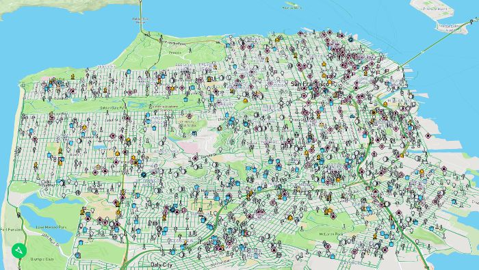
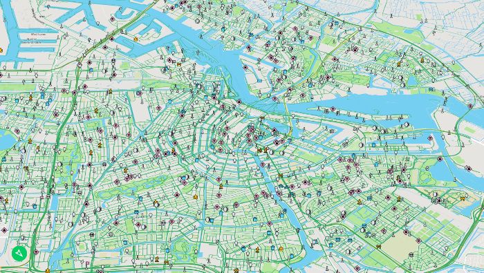
Swedish startup Mapillary has added 42 new AI-generated map feature classes to its street-level imagery platform, resulting in over 186 million extra roadside objects placed on its global map, which is available for anyone to access.  

Derived from more than 430 million images, the company’s computer vision algorithms had successfully identified and placed 186,576,130 new objects on its global map by January 11, but this figure is likely to have increased by the time of reading.

Using artificial intelligence (AI), Mapillary’s software has been trained to localize more than 42 new map feature classes, such as utility poles, fire hydrants and line features like curbs, in addition to the 1,500 different traffic sign classes that the platform has supported for some time.

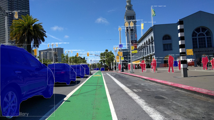
The map features are identified and put on the map through processing geo-tagged street-level images with sophisticated computer vision technology. The system detects different objects in images and reconstructs locations in 3D. If the same object has been detected in multiple images, it is possible to triangulate its position and estimate its coordinates on the map, generating a map feature that represents that item.

Mapillary’s model is based on collaboration, which means that the company has not captured any of the images that it stores on its platform. Instead, all the images have been uploaded by people and organizations around the world that are looking to access map data in the images or use them in their workflows. By uploading imagery to Mapillary, it is automatically anonymized and made available to the public. The company’s customers and partners range from mapping providers Here and Mapbox, to automotive players such as Toyota and Audi’s AID self-driving subsidiary, and cities and organizations like Amsterdam and the World Bank, as well as numerous departments of transportation (DOTs) and other road operators worldwide.

The new roadside asset map feature classes in the latest release include: fire hydrants; mailboxes; utility poles; parking meters; street lights; benches; bike racks; trash cans; manholes; crosswalks; CCTV cameras; phone booths; driveways; traffic light (various types); traffic cones; signage (various); temporary barriers; and lane marking (multiple types).

“The demand for map data is on the rise in industries ranging from mapping to automotive and governmental sectors, like transportation agencies. There’s no way any single player can map the world on their own, which is why we’ve built this collaborative and computer vision-powered model. It allows anyone to share imagery and access important information in the images through computer vision,” explained Jan Erik Solem, co-founder and CEO of Mapillary.

“The new map features are likely to be of particular interest to mapping platforms, GIS players, and agencies in the transportation field. This is something that people have asked us about for a long time. Cities are changing faster than ever before, and the old way of surveying streets is too slow, expensive, and cumbersome.

“Manual inventories usually cost US$4-US$6 per object. When you want a detailed overview of an entire city with millions of objects, the cost gets staggering high. By automating the entire process, we’re able to significantly slash both cost and time for cities, map providers, and transportation bodies.”

Share. Twitter LinkedIn Facebook Email
Previous ArticleBosch automated vehicle to start trials in Victoria
Next Article Oxfordshire highlights potential benefits of its smart city initiative
Adam Frost

Adam joined the company in 1994, and has been News Editor of TTT since 2009. In his other role as Circulation Manager, he helped create the original Traffic Technology International distribution list 23 years ago, and has been working on it ever since. Outside of work, he is a keen fisherman, runs a drumming band, and plays an ancient version of cricket.

Related Posts

Artificial Intelligence (AI)

CES 2025: Here Technologies’ AI-powered mapping technology

January 3, 20253 Mins Read
Asset Management

Flow Labs to introduce Flow RT, real-time digital twin platform, at ITS America

April 11, 20242 Mins Read
Mapping

VIDEO: Is London’s Tube map getting too complicated?

February 15, 20241 Min Read
Latest Posts
New issue graphic

Read the new TTi digital magazine online now – May 2025

May 7, 2025

Adept Live Labs 2 launches pledge to drive decarbonisation across UK highways

May 7, 2025

AUDIO: What is distracted driving?

May 7, 2025
FREE WEEKLY NEWS EMAIL!

Get the ‘best of the week’ from TrafficTechnologyToday.com direct to your inbox every Thursday


Supplier Spotlights
Our Social Channels
  • Twitter
  • YouTube
  • LinkedIn
Getting in Touch
  • Free Email Newsletters
  • Contact Us
  • Meet the Editors
  • Supplier Spotlight

Upcoming Events

May 19
May 19 - May 21

ITS European Congress – Seville 2025

May 21
May 21 - May 22

Traffex

Jun 17
June 17 - June 19

Intertraffic Americas – Mexico City 2025

View Calendar
© 2023 Mark Allen Group Ltd | All Rights Reserved
  • Cookie Policy
  • Privacy Policy
  • Terms & Conditions

Type above and press Enter to search. Press Esc to cancel.