Traffic Technology TodayTraffic Technology Today
  • News
    • A-D
      • Appointments & Staffing
      • Asset Management
      • Autonomous Vehicles & ADAS
      • Awards
      • Cloud Computing
      • Congestion Reduction
      • Connected Vehicles
      • Covid-19
      • Cybersecurity
      • Data & Modeling
      • Deals, Acquisitions & Mergers
    • E-J
      • Electric vehicles & infrastructure
      • Emissions & Low Emission Zones
      • Enforcement
      • Event News
      • Funding
      • Incident Detection
      • Infrastructure
      • Intersections & Traffic Signals
      • ITS
    • K-S
      • Legal / Government Regulation
      • Machine Vision / ALPR
      • Mapping
      • Mobility as a Service
      • Multimodality & Micromobility
      • Planning, Testing, R&D
      • Public transit
      • Safety
      • Smart Cities
      • Smart Parking
    • T-Z
      • Tolling
      • Traffic counting & categorization
      • Traffic Management
      • Traveler Information Systems
      • Tunnels & Bridges
      • Variable Message Signs
      • Vulnerable Road Users
      • Weather systems
  • Features
    • Features
    • Opinion
  • Online Magazines
    • May 2025
    • March 2025
    • December 2024
    • September 2024
    • June 2024
    • Archive Issues
    • Subscribe Free!
    • > Tolltrans
  • Video & Audio
    • Video
    • Audio
  • Podcast
  • Events
  • Webinars
  • Technology Profiles
LinkedIn YouTube X (Twitter)
Subscribe >
Traffic Technology TodayTraffic Technology Today
  • News
      • Appointments & Staffing
      • Asset Management
      • Autonomous Vehicles & ADAS
      • Awards
      • Cloud Computing
      • Congestion Reduction
      • Connected Vehicles
      • Covid-19
      • Cybersecurity
      • Data & Modeling
      • Deals, Acquisitions & Mergers
      • Electric vehicles & infrastructure
      • Emissions & Low Emission Zones
      • Enforcement
      • Event News
      • Funding
      • Incident Detection
      • Infrastructure
      • Intersections & Traffic Signals
      • ITS
      • Legal / Government Regulation
      • Machine Vision / ALPR
      • Mapping
      • Mobility as a Service
      • Multimodality & Micromobility
      • Planning, Testing, R&D
      • Public transit
      • Safety
      • Smart Cities
      • Smart Parking
      • Tolling
      • Traffic counting & categorization
      • Traffic Management
      • Traveler Information Systems
      • Tunnels & Bridges
      • Variable Message Signs
      • Vulnerable Road Users
      • Weather systems
  • Features
    • Features
    • Opinion
  • Online Magazines
    1. May 2025
    2. March 2025
    3. December 2024
    4. September 2024
    5. June 2024
    6. March 2024
    7. Archive Issues
    8. Subscribe Free!
    9. > Tolltrans
    Featured
    New issue graphic
    May 7, 2025

    Read the new TTi digital magazine online now – May 2025

    ITS By Tom Stone
    Recent
    New issue graphic

    Read the new TTi digital magazine online now – May 2025

    May 7, 2025

    NEW TTi MAGAZINE! Read the March 2025 digital edition online now

    March 21, 2025

    Digital magazine – read the new issue of TTi online for free – December 2024

    December 12, 2024
  • Video & Audio
    • Video
    • Audio
  • Podcast
  • Events
  • Webinars
  • Technology Profiles
LinkedIn YouTube X (Twitter)
Traffic Technology TodayTraffic Technology Today
Congestion Reduction

Purdue University’s drone technology improves crash site assessments

Adam FrostBy Adam FrostJanuary 21, 20193 Mins Read
Share LinkedIn Twitter Facebook Email
Purdue University’s drone technology improves crash site assessments

At a presentation during last week’s annual Transportation Research Board (TRB) meeting in Washington DC, researchers from Purdue University showed how highway crash assessments could be completed safer, faster and more accurately using their newly-developed drone technology.  

According to the US Department of Transportation’s (USDOT) Federal Highway Administration (FHWA), slowed or stationary traffic on a busy highway is one of the most vulnerable times for ‘secondary accidents’, which are often worse than the original source of an incident.

Figures show that secondary crashes go up by a factor of almost 24 during the time that highway safety officials are assessing and documenting the original crash site. Conventional mapping of a severe or fatal crash can take two to three hours depending on the severity of the accident.

However, photogrammetric procedures for data collection using a drone that have been developed by the Purdue team can map a scene in five to eight minutes, allowing public safety officers to open the roads much quicker after an accident.

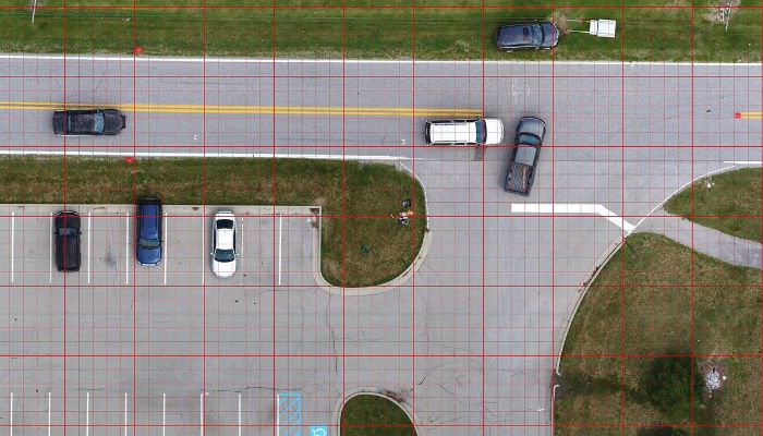
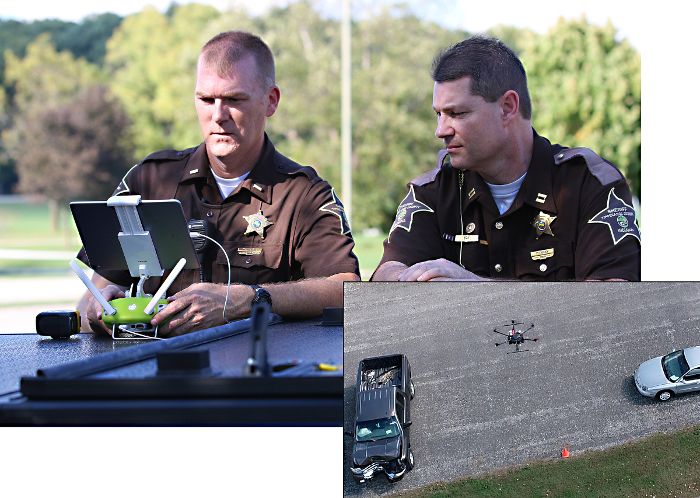
John Bullock, a research assistant on the project from Purdue’s School of Mechanical Engineering, worked with local public safety colleagues to develop field procedures and post processing of images to create orthorectified images that clearly illustrate the position of vehicles, infrastructure and general terrain adjacent to the crash site.

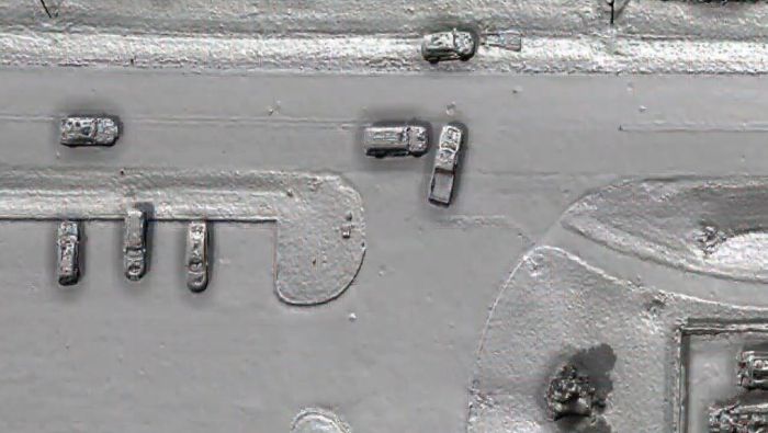
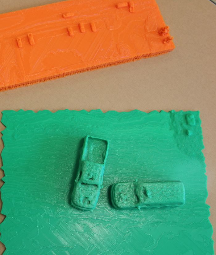
The drones are programmed to use a grid-type path and record about 100 photos in two-second intervals. This post processed data is used to develop an accurate scale map that, with photos at the scene, provides enough data to create a 3D print of the scene.

The technology has been trialled by the Tippecanoe County Sheriff’s Office in Indiana, which used drones to map crash scenes 20 times in 2018, and another 15 times in the same year to support specialty law enforcement teams throughout the county and in neighboring counties and jurisdictions.

“The technology is so much faster than traditional ground-based measurements and provides a much better comprehensive documentation that it opens up all different kinds of research,” explained Professor Ayman Habib from Purdue University.

“It can provide high-quality maps, imagery and models for post-crash investigation by engineers and public safety officials. This technology has many other civil engineering applications beyond crash scene mapping and can be used to estimate the volume of material needed or used for a construction project within a couple of percentage points.

“It is very rewarding to see how this technology can be used to improve safety by reducing secondary crashes and exposure of colleagues to the hazards of working adjacent to highway traffic.”

Captain Robert Hainje of the Tippecanoe County Sheriff’s Office commented, “Overall, it can cut 60% off the down time for traffic flow following a crash. The collaboration with Purdue faculty and students has been tremendously effective in helping our law enforcement, first responders and special teams.

“The drone technology with the thermal imaging capability also helps with all types of emergencies such as search and rescue, aerial support over water for diver teams or in wooded areas and for fugitive apprehension.”

Purdue University’s drone technology improves crash site assessments

Share. Twitter LinkedIn Facebook Email
Previous ArticleSpark selected for UK’s Intelligent Mobility Accelerator program
Next Article Japanese ITS waveband-based V2X system demonstrated in India
Adam Frost

Adam joined the company in 1994, and has been News Editor of TTT since 2009. In his other role as Circulation Manager, he helped create the original Traffic Technology International distribution list 23 years ago, and has been working on it ever since. Outside of work, he is a keen fisherman, runs a drumming band, and plays an ancient version of cricket.

Related Posts

Downtown from Corona Heights, California.
Traffic Management

Corona, California, awards Iteris $4m smart mobility contract

May 1, 20252 Mins Read
Tolling

Q-Free deploys its first Kinetic Mobility ATMS in the US on three toll roads

April 30, 20253 Mins Read
Incident Detection

TECH PROFILE: Reliable vehicle detection in any conditions

April 17, 20254 Mins Read
Latest Posts
Fibes Exhibition Centre, Seville

EXCLUSIVE: ITS European Congress Guide

May 9, 2025
New issue graphic

Read the new TTi digital magazine online now – May 2025

May 7, 2025

Adept Live Labs 2 launches pledge to drive decarbonisation across UK highways

May 7, 2025
FREE WEEKLY NEWS EMAIL!

Get the ‘best of the week’ from TrafficTechnologyToday.com direct to your inbox every Thursday


Supplier Spotlights
Our Social Channels
  • Twitter
  • YouTube
  • LinkedIn
Getting in Touch
  • Free Email Newsletters
  • Contact Us
  • Meet the Editors
  • Supplier Spotlight

Upcoming Events

May 19
May 19 - May 21

ITS European Congress – Seville 2025

May 21
May 21 - May 22

Traffex

Jun 17
June 17 - June 19

Intertraffic Americas – Mexico City 2025

View Calendar
© 2023 Mark Allen Group Ltd | All Rights Reserved
  • Cookie Policy
  • Privacy Policy
  • Terms & Conditions

Type above and press Enter to search. Press Esc to cancel.