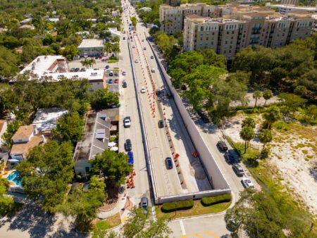
The Contra Costa Transportation Authority (CCTA) and Alta Vista Solutions have showcased the combined use of lidar and drone technologies on a construction project aimed at improving commutes on Highway 4 in California.
Engineers are piloting drones equipped with lidar lasers, which are used as a surveying tool to create high-resolution geographical data. The combination of the two emerging technologies has never been used in a construction project before, and opens up many possibilities for unmanned aerial vehicle (UAV) technology in the future.
With assistance from engineering consultancy Alta Vista, who proposed the new method, CCTA is flying the lidar scanners to measure the volumes of earth that need to be moved during the US$74m project to rework the Balfour Road interchange. The drones ensure that the cut-and-fill earthwork goes efficiently.
With lidar’s pinpoint accuracy, CCTA can now make needed calculations and monitor site conditions faster, eliminating the unavoidable guesswork involved in manual surveys. Putting lidar on drones gathers 15 gigabytes of precise, high-quality data per month, cutting down drastically on time spent surveying, while also improving safety by taking workers out of live traffic. As work on Highway 4 continues, the drone’s capabilities will enable CCTA to track construction progress first hand.
“We are always looking for new ways to increase safety and efficiency on construction projects,” said CCTA’s director, Randy Iwasaki. “Drones give us aerial views of the site that were hard to come by before, making it safer for surveyors to do their job, and helping us manage the large volumes of dirt that are being used to improve this intersection. This technology also allows us to monitor environmentally sensitive areas without disturbing the habitat. I believe we’ll start to see more widespread use of drones on construction sites within a few years, especially as we discover new applications that can help save time and money.”
Ed Greutert, principal engineer at Alta Vista, commented, “This will change engineering and surveying. Innovations like combining lidar and UAVs are opening doors in infrastructure and making us efficient, effective and safe in ways we couldn’t achieve before. Lidar on a UAV hasn’t worked until now; there are huge possibilities if we can be creative enough to really tap into them. It’s going to create new jobs in technology, and in the Balfour Road case, help people get to work faster.”


