


Once curbs were either places you were allowed to park or not. Today, this infrastructure is under growing pressure from a surge in home deliveries, ride-hailing apps, micromobility, EV charging and more. Tom Stone takes a closer look at some of the software solutions helping cities to manage this valuable asset more effectively
The humble curb – the meeting point between vehicle lanes and pedestrian sidewalks – has become one of the most hotly contested and valuable pieces of real estate in cities. As urban mobility patterns evolve and new transportation technologies emerge, effectively managing this crucial interface has never been more important.
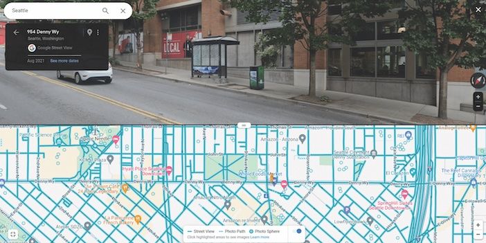
Municipalities are increasingly employing full-time curbside managers to help oversee this important asset. “Cities from Seattle to Melbourne have people dedicated to curbside management,” says Peter Richards product director and creator of CurbIQ, a software company within the broader Arcadis organization that’s helping cities tackle this growing challenge.
“The curb is the most important piece of urban mobility infrastructure in cities today,” he continues “Ten years ago, the word curbside didn’t mean much to most people. But then when Amazon and other deliveries accelerated, and as Uber and Lyft have come to prominence, everyone’s using the curb that has traditionally either been designated for parking or simply kept clear.”
“Cities from Seattle to Melbourne have people dedicated to curbside management. The curb is the most important piece of urban mobility infrastructure in cities today”
Peter Richards, product director, CurbIQ
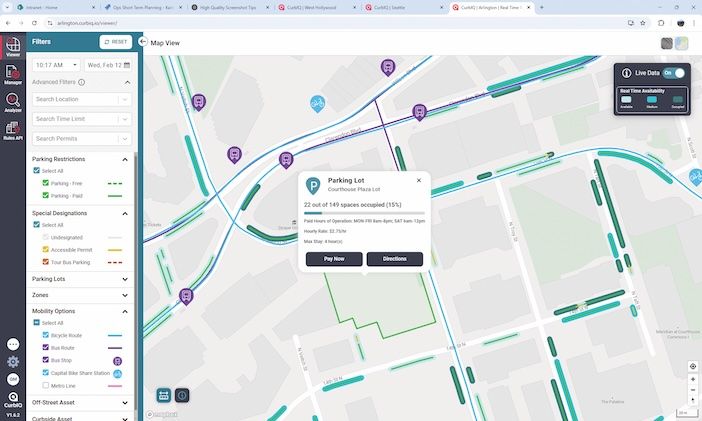
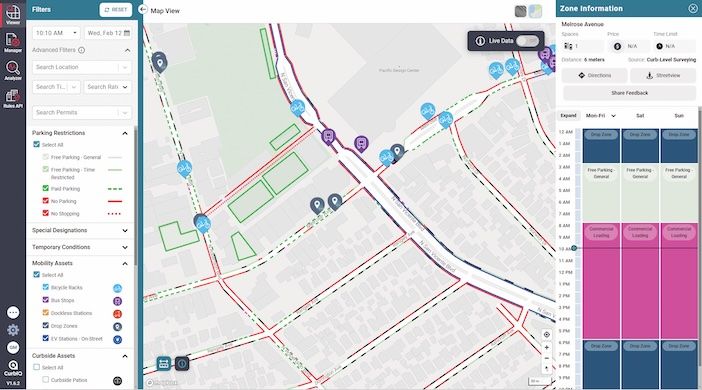
Whereas in the past curbside management would be analogue and ad hoc, today digital tools give cities granular insight into how their curbs are being used. CurbIQ’s software solution digitizes street regulations and presents them in an intuitive geographical information system (GIS), allowing cities to visualize and analyze their curbside assets in real-time.
The challenge for many cities is that their curbside data exists in multiple, disconnected systems. “Cities also work with a lot of vendors and therefore they have a lot of different dashboards that don’t talk to one another,” says Richards. “CurbIQ helps consolidate this information so it’s all in one place.”
To assist with this consolidation industry standards have been developed for the aggregation of data: CDS, D-TRO and CurbLR. These open-data standards help government agencies to effectively manage, regulate and share curbside data, supporting public and private users of city streets. CurbIQ uses and outputs to these standards to make the sharing of data straightforward.
“Parking restrictions are typically stored as point-based asset data. The assets themselves are easy to map, but the concepts they represent are not”
Emily Eros, writing when product lead of the Open Transport Partnership

The data standards create a common language which can help with building rules engines, query APIs, consumer services, GIS, and analytic models. Linear referencing links regulation information back to the street, making the data easy to use on other maps.
“Parking restrictions are typically stored as point-based asset data. The assets themselves are easy to map, but the concepts they represent are not,” wrote Emily Eros in a blog as product lead for the Open Transport Partnership. “Curb regulations don’t have a perfect, 1:1 relationship with physical space.”
Inrix is another company offering a curbside management platform. Its cloud-based IQ Curb Analytics was launched in August 2024 to help manage access, revenue and safety at the curb, balancing the needs of different stakeholders. “Curbs are complex entities that require meticulous planning to maximize their use,” says Ahmed Darrat, chief product officer at Inrix. “Curb Analytics leverages Inrix’s robust datasets across traffic, incident, parking, and safety to provide a comprehensive digital view of curb usage in cities across the US and Europe,”
Data collection
The process of building a comprehensive curbside management system begins with gathering accurate data. However, not all cities have complete digital records of their signage and curb paint. “A lot of cities don’t have this,” says Richards. “If they don’t have a complete data set, we need walk the streets and take photos of the information to geo-locate it, and then we digitize it and put it into CurbIQ.”
“Many rules and regulations are not signed at all, inconsistently signed, globally handled through city and state laws, or demarcated with other right-of-way features”
Ahmed Darrat, chief product officer, Inrix
Darrat also warns: “Many rules and regulations are not signed at all, inconsistently signed, globally handled through city and state laws, or demarcated with other right-of-way features such as paint or curbs. Our analysis found segmentation of the curb zones can be as low as 55% accurate. This alarming statistic highlights a critical gap in how cities currently track and manage their curb space.”
The problem goes beyond just missing signs. Driveways, bus stops, and intersection clear zones often go unrecorded. In New York’s Tribeca district driveways account for 2.5% of on-street spaces – a significant number that often goes unmapped. In less dense neighborhoods, the impact is even more pronounced.
Rather than relying solely on sign inventories or expensive lidar scanning, Inrix maintains up-to-date curb data across more than 125 cities in the US and Europe. “We’re able to do this because we have dozens of existing customers that require the data to stay up to date and also provide feedback into our system,” says Darrat.
Keeping it real
Real-time data is also an important part of curbside management at it brings a further level of functionality. “Some cities have sensors or cameras and we can ingest their data, feed their API and show that real-time data,” says Richards. “We can also pull in transaction data so when you pay for parking or if there are smart parking metres, we can get anonymized real-time occupancy data.”

This real-time insight allows cities to make more informed decisions about curbside use and helps reduce congestion by guiding drivers directly to available spaces.
In Edmonton, Alberta occupancy data for around 4,000 parking spaces are connected to an app. “You can see that on a street with 20 spaces, 15 have been paid for,” says Richards. “So you can make a decision to head there… That really reduces cruising and circling for parking, reduces vehicle miles traveled and results in a better customer experience.”
Hollywood stars
A recent deployment in West Hollywood, California, demonstrates the comprehensive nature of modern curbside management. “West Hollywood is a pretty innovative city, they wanted to implement a smart curbside management system for the next five years,” says Richards. “They have lots of curbside use, lots of movie shoots and famous music venues – a lot is happening there.”

The city needed to understand space-by-space usage across its entire territory, but faced challenges with fragmented data. “They had several datasets: internal GIS libraries, Excel sheets… all these different sources, but they had lots of gaps,” says Richards. The solution involved both consolidating existing data and conducting detailed on-street surveys to create a comprehensive digital inventory.
The city is looking to use CurbIQ to manage various aspects of curbside use, including encroachment permits and special events. “CurbIQ can provide permit visualization and management,” says Richards. “So now the city can understand and quantify the number of permit types and space across the entire city.”
Balancing demands
While most cities in the world don’t have to deal with managing permits for film crews on a regular basis, balancing the needs of various stakeholders is common. “In Toronto we realized there were almost 20 different stakeholders… emergency services, accessible badges, you name it,” says Richards.
The key to managing these competing demands lies in understanding the intended function of different street types. “Do you people traveling 50mph down your high street? Or do you want outdoor dining and pick up and drop off areas?” asks Richards. “It’s important to understand and reconcile these functions with the street types and understand the hierarchy of needs at the curbside.”
The pandemic has further complicated this balance by accelerating changes in how curbs are used. “Covid really accelerated curbside pickup,” says Richards. “One solution is that cities are putting in 15-minute pick up and drop off zones in busy areas, so Deliveroo or Uber Eats or whomever can use the space they’re given, because otherwise they end up double parking or parking on the sidewalk.”
Curbside data can also help cities to predict the impacts of dedicating curb space to EV charging, by establishing how much such spaces are already used. “If a city or local authority wants to put in an on-street EV charging bay they’ll usually repurpose an existing parking bay. They’ll need to establish the impacts of this on the local neighborhood.”
Connected curbsides
The importance of effective curbside management will increase with the emergence of new technologies and mobility patterns. Richards anticipates increased connectivity: “You’ll have curbside infrastructure becoming smarter, talking to vehicles, maybe taking payments and reservations from vehicles and that may tie in with electronic signage.”
This will be particularly crucial for autonomous vehicles. “Until now, the discussion around AVs has been mainly about ensuring safe travel speeds and changing lanes and awareness of objects,” Richards notes. “But now there’s demand that they’re competing for space on the curbside and these companies need to know where they can safely and legally pick up and drop off passengers and goods.”
Richards also sees potential for new data collection methods. “Maybe drones could be used to improve cost effectiveness of surveys and data collection,” he says.
The evolution of curbside management reflects a change in how we think about urban space. As cities become more connected and transportation options more diverse, the ability to effectively manage the curb will become increasingly vital to creating efficient, livable urban environments.“You’re not going to make everyone happy, but you need to show them there is a process,” says Richards. “It’s not the loudest voice, it is equitable. And here’s data.”
This article was first published in the March 2025 edition of TTi magazine


