Traffic Technology TodayTraffic Technology Today
  • News
    • A-D
      • Appointments & Staffing
      • Asset Management
      • Autonomous Vehicles & ADAS
      • Awards
      • Cloud Computing
      • Congestion Reduction
      • Connected Vehicles
      • Covid-19
      • Cybersecurity
      • Data & Modeling
      • Deals, Acquisitions & Mergers
    • E-J
      • Electric vehicles & infrastructure
      • Emissions & Low Emission Zones
      • Enforcement
      • Event News
      • Funding
      • Incident Detection
      • Infrastructure
      • Intersections & Traffic Signals
      • ITS
    • K-S
      • Legal / Government Regulation
      • Machine Vision / ALPR
      • Mapping
      • Mobility as a Service
      • Multimodality & Micromobility
      • Planning, Testing, R&D
      • Public transit
      • Safety
      • Smart Cities
      • Smart Parking
    • T-Z
      • Tolling
      • Traffic counting & categorization
      • Traffic Management
      • Traveler Information Systems
      • Tunnels & Bridges
      • Variable Message Signs
      • Vulnerable Road Users
      • Weather systems
  • Features
    • Features
    • Opinion
  • Online Magazines
    • May 2025
    • March 2025
    • December 2024
    • September 2024
    • June 2024
    • Archive Issues
    • Subscribe Free!
    • > Tolltrans
  • Video & Audio
    • Video
    • Audio
  • Podcast
  • Events
  • Webinars
  • Technology Profiles
LinkedIn YouTube X (Twitter)
Subscribe >
Traffic Technology TodayTraffic Technology Today
  • News
      • Appointments & Staffing
      • Asset Management
      • Autonomous Vehicles & ADAS
      • Awards
      • Cloud Computing
      • Congestion Reduction
      • Connected Vehicles
      • Covid-19
      • Cybersecurity
      • Data & Modeling
      • Deals, Acquisitions & Mergers
      • Electric vehicles & infrastructure
      • Emissions & Low Emission Zones
      • Enforcement
      • Event News
      • Funding
      • Incident Detection
      • Infrastructure
      • Intersections & Traffic Signals
      • ITS
      • Legal / Government Regulation
      • Machine Vision / ALPR
      • Mapping
      • Mobility as a Service
      • Multimodality & Micromobility
      • Planning, Testing, R&D
      • Public transit
      • Safety
      • Smart Cities
      • Smart Parking
      • Tolling
      • Traffic counting & categorization
      • Traffic Management
      • Traveler Information Systems
      • Tunnels & Bridges
      • Variable Message Signs
      • Vulnerable Road Users
      • Weather systems
  • Features
    • Features
    • Opinion
  • Online Magazines
    1. May 2025
    2. March 2025
    3. December 2024
    4. September 2024
    5. June 2024
    6. March 2024
    7. Archive Issues
    8. Subscribe Free!
    9. > Tolltrans
    Featured
    New issue graphic
    May 7, 2025

    Read the new TTi digital magazine online now – May 2025

    ITS By Tom Stone
    Recent
    New issue graphic

    Read the new TTi digital magazine online now – May 2025

    May 7, 2025

    NEW TTi MAGAZINE! Read the March 2025 digital edition online now

    March 21, 2025

    Digital magazine – read the new issue of TTi online for free – December 2024

    December 12, 2024
  • Video & Audio
    • Video
    • Audio
  • Podcast
  • Events
  • Webinars
  • Technology Profiles
LinkedIn YouTube X (Twitter)
Traffic Technology TodayTraffic Technology Today
Mapping

Bluesky uses Leica CityMapper to capture detailed 3D imagery of major UK cities

Adam FrostBy Adam FrostNovember 23, 20183 Mins Read
Share LinkedIn Twitter Facebook Email

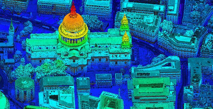
Aerial survey company Bluesky has used the Leica CityMapper, the world’s first hybrid airborne camera combining vertical and oblique imagery together with 3D laser scanning, to capture major cities throughout the UK, to provide urban planners and asset managers with new visualizations.

Using the CityMapper system, Bluesky was able to capture parts of London, Manchester and Birmingham, as well as Brighton, Bristol, Cambridge, Norwich, Nottingham and Oxford. Bluesky intends to increase its coverage by capturing additional towns and cities across the UK and Ireland in 2019. It is the first time this technology has been used commercially in the UK to this level.

The captured city data is currently available from Bluesky and Leica Geosystems, part of the Swedish Hexagon Geosystems group, in its constituent components of vertical orthorectified aerial imagery, oblique photographs and lidar point cloud data. Plans are in place to also include the imagery in the HxGN Content Program in the near future.

The Leica CItyMapper system includes a traditional vertical camera as well as survey-grade oblique cameras. Specially designed for 3D city modeling and urban mapping, the sensor also includes high performance lidar technology to accurately collect elevation data even into the shadows, which are common in urban environments and make photo-based data collection difficult. The CityMapper sensor also collects color infrared data, which can be used to aid greenspace mapping and vegetation studies.

Applications of the new Bluesky 3D models are expected to include urban planning, line of sight analysis, new development visualizations, environmental modeling and potentially 3D fly throughs and virtual reality experiences. Early adopters of the data include local authorities, asset managers, architects, planning consultants and other map publishers.

“The combination of multiple survey grade cameras and lidar enables, for the first time, the simultaneous capture of data for the automatic creation of highly accurate and detailed citywide 3D models, with one sensor,” said Rachel Tidmarsh, Bluesky’s managing director.

“While 3D models have been around for a number of years, they have either been prohibitively expensive for use across larger areas or of insufficient detail or accuracy. Using the CityMapper sensor, we can achieve efficient, and therefore cost effective, capture of highly detailed and accurate data, making widespread use of 3D models a reality.”

Ron Roth, geospatial content solutions product manager for airborne topographic lidar at Leica Geosystems, commented, “The CityMapper was designed for just this type of use; capturing the many layers of urban environments. We are excited to see the high-quality data Bluesky has been able to produce with CityMapper, and we are sure many customers will benefit from this capture.”

Share. Twitter LinkedIn Facebook Email
Previous ArticleLexus Australia to conduct two-year cooperative-ITS trial in Queensland
Next Article RoadBotics raises new funding to further develop its app-based road inspection system
Adam Frost

Adam joined the company in 1994, and has been News Editor of TTT since 2009. In his other role as Circulation Manager, he helped create the original Traffic Technology International distribution list 23 years ago, and has been working on it ever since. Outside of work, he is a keen fisherman, runs a drumming band, and plays an ancient version of cricket.

Related Posts

Artificial Intelligence (AI)

CES 2025: Here Technologies’ AI-powered mapping technology

January 3, 20253 Mins Read
Asset Management

Flow Labs to introduce Flow RT, real-time digital twin platform, at ITS America

April 11, 20242 Mins Read
Mapping

VIDEO: Is London’s Tube map getting too complicated?

February 15, 20241 Min Read
Latest Posts
Fibes Exhibition Centre, Seville

EXCLUSIVE: ITS European Congress Guide

May 9, 2025
New issue graphic

Read the new TTi digital magazine online now – May 2025

May 7, 2025

Adept Live Labs 2 launches pledge to drive decarbonisation across UK highways

May 7, 2025
FREE WEEKLY NEWS EMAIL!

Get the ‘best of the week’ from TrafficTechnologyToday.com direct to your inbox every Thursday


Supplier Spotlights
Our Social Channels
  • Twitter
  • YouTube
  • LinkedIn
Getting in Touch
  • Free Email Newsletters
  • Contact Us
  • Meet the Editors
  • Supplier Spotlight

Upcoming Events

May 19
May 19 - May 21

ITS European Congress – Seville 2025

May 21
May 21 - May 22

Traffex

Jun 17
June 17 - June 19

Intertraffic Americas – Mexico City 2025

View Calendar
© 2023 Mark Allen Group Ltd | All Rights Reserved
  • Cookie Policy
  • Privacy Policy
  • Terms & Conditions

Type above and press Enter to search. Press Esc to cancel.