Traffic Technology TodayTraffic Technology Today
  • News
    • A-D
      • Appointments & Staffing
      • Asset Management
      • Autonomous Vehicles & ADAS
      • Awards
      • Cloud Computing
      • Congestion Reduction
      • Connected Vehicles
      • Covid-19
      • Cybersecurity
      • Data & Modeling
      • Deals, Acquisitions & Mergers
    • E-J
      • Electric vehicles & infrastructure
      • Emissions & Low Emission Zones
      • Enforcement
      • Event News
      • Funding
      • Incident Detection
      • Infrastructure
      • Intersections & Traffic Signals
      • ITS
    • K-S
      • Legal / Government Regulation
      • Machine Vision / ALPR
      • Mapping
      • Mobility as a Service
      • Multimodality & Micromobility
      • Planning, Testing, R&D
      • Public transit
      • Safety
      • Smart Cities
      • Smart Parking
    • T-Z
      • Tolling
      • Traffic counting & categorization
      • Traffic Management
      • Traveler Information Systems
      • Tunnels & Bridges
      • Variable Message Signs
      • Vulnerable Road Users
      • Weather systems
  • Features
    • Features
    • Opinion
  • Online Magazines
    • May 2025
    • March 2025
    • December 2024
    • September 2024
    • June 2024
    • Archive Issues
    • Subscribe Free!
    • > Tolltrans
  • Video & Audio
    • Video
    • Audio
  • Podcast
  • Events
  • Webinars
  • Technology Profiles
LinkedIn YouTube X (Twitter)
Subscribe >
Traffic Technology TodayTraffic Technology Today
  • News
      • Appointments & Staffing
      • Asset Management
      • Autonomous Vehicles & ADAS
      • Awards
      • Cloud Computing
      • Congestion Reduction
      • Connected Vehicles
      • Covid-19
      • Cybersecurity
      • Data & Modeling
      • Deals, Acquisitions & Mergers
      • Electric vehicles & infrastructure
      • Emissions & Low Emission Zones
      • Enforcement
      • Event News
      • Funding
      • Incident Detection
      • Infrastructure
      • Intersections & Traffic Signals
      • ITS
      • Legal / Government Regulation
      • Machine Vision / ALPR
      • Mapping
      • Mobility as a Service
      • Multimodality & Micromobility
      • Planning, Testing, R&D
      • Public transit
      • Safety
      • Smart Cities
      • Smart Parking
      • Tolling
      • Traffic counting & categorization
      • Traffic Management
      • Traveler Information Systems
      • Tunnels & Bridges
      • Variable Message Signs
      • Vulnerable Road Users
      • Weather systems
  • Features
    • Features
    • Opinion
  • Online Magazines
    1. May 2025
    2. March 2025
    3. December 2024
    4. September 2024
    5. June 2024
    6. March 2024
    7. Archive Issues
    8. Subscribe Free!
    9. > Tolltrans
    Featured
    New issue graphic
    May 7, 2025

    Read the new TTi digital magazine online now – May 2025

    ITS By Tom Stone
    Recent
    New issue graphic

    Read the new TTi digital magazine online now – May 2025

    May 7, 2025

    NEW TTi MAGAZINE! Read the March 2025 digital edition online now

    March 21, 2025

    Digital magazine – read the new issue of TTi online for free – December 2024

    December 12, 2024
  • Video & Audio
    • Video
    • Audio
  • Podcast
  • Events
  • Webinars
  • Technology Profiles
LinkedIn YouTube X (Twitter)
Traffic Technology TodayTraffic Technology Today
Asset Management

North Carolina conducts further research into drone use for highway crash reconstructions

Tom StoneBy Tom StoneAugust 9, 20183 Mins Read
Share LinkedIn Twitter Facebook Email

Following successful trials in 2017, the North Carolina Department of Transportation (NCDOT) is continuing to research ways to use emerging drone or unmanned aerial system (UAS) technology to make highway travel safer.

Last year, NCDOT’s Division of Aviation and the NC State Highway Patrol (NCSHP) studied the use of drones for highway collision scene reconstructions, and found that they can save money and reduce the time a roadway must be closed during a reconstruction.

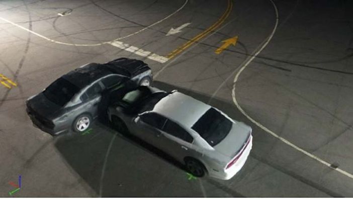
NCDOT’s Photogrammetry Unit studied the feasibility of using drones to create 3D models of collision scenes and compared the results against those collected by the NCSHP’s Collision Reconstruction Unit using a traditional laser scanner.

The teams found that using drones cuts the time needed to perform an accurate reconstruction from 1 hour 51 minutes to just 25 minutes. Crews could start clearing the crash scene more than an hour earlier, meaning traffic could start moving again faster. Drones also significantly reduce the risk posed to personnel involved, provide an aerial perspective of the scene, and are cheaper and easier to use than current technologies.

To follow up, the groups involved wanted to study using drones in low-light reconstructions to see if it was possible and, if so, how much and what type of lighting would have to be brought to a scene. A new study was commissioned by NCDOT and NCSHP, with the project conducted by non-profit research institute RTI International and the University of North Carolina at Charlotte (UNC Charlotte).

Key findings from the study were:

• Drone data can provide evidence-grade images in some low-light conditions when supplemented with appropriate external lighting equipment;

• Drones can provide report-grade images that will add value to collision scene reports in most low-light conditions, even if the data is not of sufficient quality to be used as evidence in court;

• Two drones, the DJI Phantom 4 Pro and the DJI Mavic Pro, were compared and the Phantom 4 was found to be more suitable, because its larger camera sensor is sufficiently sensitive for use in low light situations, and is more stable in windy conditions;

• The quality of reconstructions in twilight conditions, when there is sufficient ambient light to view the car features and Ground Control Points, is better than for night-time conditions with artificial lights;

• The external lighting systems had the greatest impact on data quality;

• Mobile light towers are more effective than inflatable light towers for illuminating the scene, as they have a higher luminous intensity;

• Grid trajectories provide better orthomosaics; whereas, orbit trajectories provide 3-D reconstructions with better lateral feature reconstructions. Using both double grid and orbit trajectories to record combined image datasets is recommended.

“Last year’s study was groundbreaking,” said Basil Yap, manager of NCDOT’s UAS Program Office. “We found that not only does it save thousands of dollars, but using drones instead of traditional ground-based reconstruction techniques also cuts the time each reconstruction takes from almost two hours to less than half an hour.”

RTI’s lead researcher, Joe Eyerman, commented, “Provided they use the right kind of equipment, drones are capable of producing high-quality collision reconstructions in darker settings. Obviously, many collisions occur in less-than-perfect conditions, so knowing that the Highway Patrol can still use this technology is great news.”

Share. Twitter LinkedIn Facebook Email
Previous ArticleScottish LED road stud safety scheme in contention for major UK transport industry award
Next Article Emovis wins IBTTA’s 2018 Toll Excellence Award for ‘Private Sector Innovation’
Tom Stone

Tom has edited Traffic Technology International (TTi) magazine and its Traffic Technology Today website since May 2014. During his time at the title, he has interviewed some of the top transportation chiefs at public agencies around the world as well as CEOs of leading multinationals and ground-breaking start-ups. Tom's earlier career saw him working on some the UK's leading consumer magazine titles. He has a law degree from the London School of Economics (LSE).

Related Posts

Funding

Podcast 49: Kirk Steudle on the new US Administration, public vs private and the future of ITS

May 2, 20251 Min Read
Downtown from Corona Heights, California.
Traffic Management

Corona, California, awards Iteris $4m smart mobility contract

May 1, 20252 Mins Read
Tolling

Q-Free deploys its first Kinetic Mobility ATMS in the US on three toll roads

April 30, 20253 Mins Read
Latest Posts
Fibes Exhibition Centre, Seville

EXCLUSIVE: ITS European Congress Guide

May 9, 2025
New issue graphic

Read the new TTi digital magazine online now – May 2025

May 7, 2025

Adept Live Labs 2 launches pledge to drive decarbonisation across UK highways

May 7, 2025
FREE WEEKLY NEWS EMAIL!

Get the ‘best of the week’ from TrafficTechnologyToday.com direct to your inbox every Thursday


Supplier Spotlights
Our Social Channels
  • Twitter
  • YouTube
  • LinkedIn
Getting in Touch
  • Free Email Newsletters
  • Contact Us
  • Meet the Editors
  • Supplier Spotlight

Upcoming Events

May 19
May 19 - May 21

ITS European Congress – Seville 2025

May 21
May 21 - May 22

Traffex

Jun 17
June 17 - June 19

Intertraffic Americas – Mexico City 2025

View Calendar
© 2023 Mark Allen Group Ltd | All Rights Reserved
  • Cookie Policy
  • Privacy Policy
  • Terms & Conditions

Type above and press Enter to search. Press Esc to cancel.